What Is an Atmospheric River? The AR Scale, the Pineapple Express, and El Niño
Learn what an atmospheric river is, how the AR 1 to 5 scale works, what a Pineapple Express is, and whether a very strong El Niño means more of them for the West Coast this winter.
Quick Answer: What Is an Atmospheric River?
An atmospheric river is a long, narrow band of concentrated water vapor moving through the lower atmosphere, like a river in the sky. When one comes ashore and is forced up over hills and mountains, that vapor condenses into rain and snow, often for a day or more at a stretch.
| Feature | What to Know |
|---|---|
| Shape | Often more than 1,000 miles long, typically 250 to 375 miles wide |
| Water carried | An average one moves about as much water vapor as the Mississippi River discharges at its mouth |
| Where the water is | Mostly in the lowest two miles of the atmosphere |
| What sets it off | Landfall and lift over terrain, which wrings the vapor out as rain and snow |
| How it is rated | The AR scale, from AR 1 (weak) to AR 5 (exceptional) |
| Why it matters | Atmospheric rivers supply 30 to 50% of the West Coast's yearly precipitation and cause most of its flood damage |
If you only remember one thing: atmospheric rivers are both the West's water supply and its main flood threat. Which one you get depends on how strong the river is and how long it stays.
How an Atmospheric River Works
Most of the water vapor in the atmosphere sits over the warm tropical and subtropical oceans. Atmospheric rivers are how a large share of it travels toward the poles. A handful of them are active around the globe at any moment.
They form alongside ordinary mid-latitude storms. Ahead of a storm's cold front, a fast stream of low-level wind gathers moist air into a narrow corridor and carries it along, often for more than a thousand miles. If you have read our guide to high- and low-pressure systems, this is the warm, moist conveyor on the leading side of the low.
Over open ocean, an atmospheric river is mostly invisible weather: a plume of humid air with some cloud and light rain. The real effects begin at the coast. When that plume runs into the Coast Ranges, the Cascades, or the Sierra Nevada, the air has nowhere to go but up. Rising air cools, cooled vapor condenses, and the mountains squeeze out rain and snow for as long as the plume keeps pointing at them. Forecasters call this orographic lift, and it is why totals on a mountain's windward slope can be several times what falls in the valley below.
NOAA puts the scale in perspective: an average atmospheric river carries roughly as much water vapor as the average flow at the mouth of the Mississippi River, and an exceptional one can carry up to 15 times that.
What Is a Pineapple Express?
A Pineapple Express is one particular kind of atmospheric river: a strong one that draws its moisture from the tropics near Hawaii and delivers it to the U.S. or Canadian West Coast. The name comes from the plume's starting point.
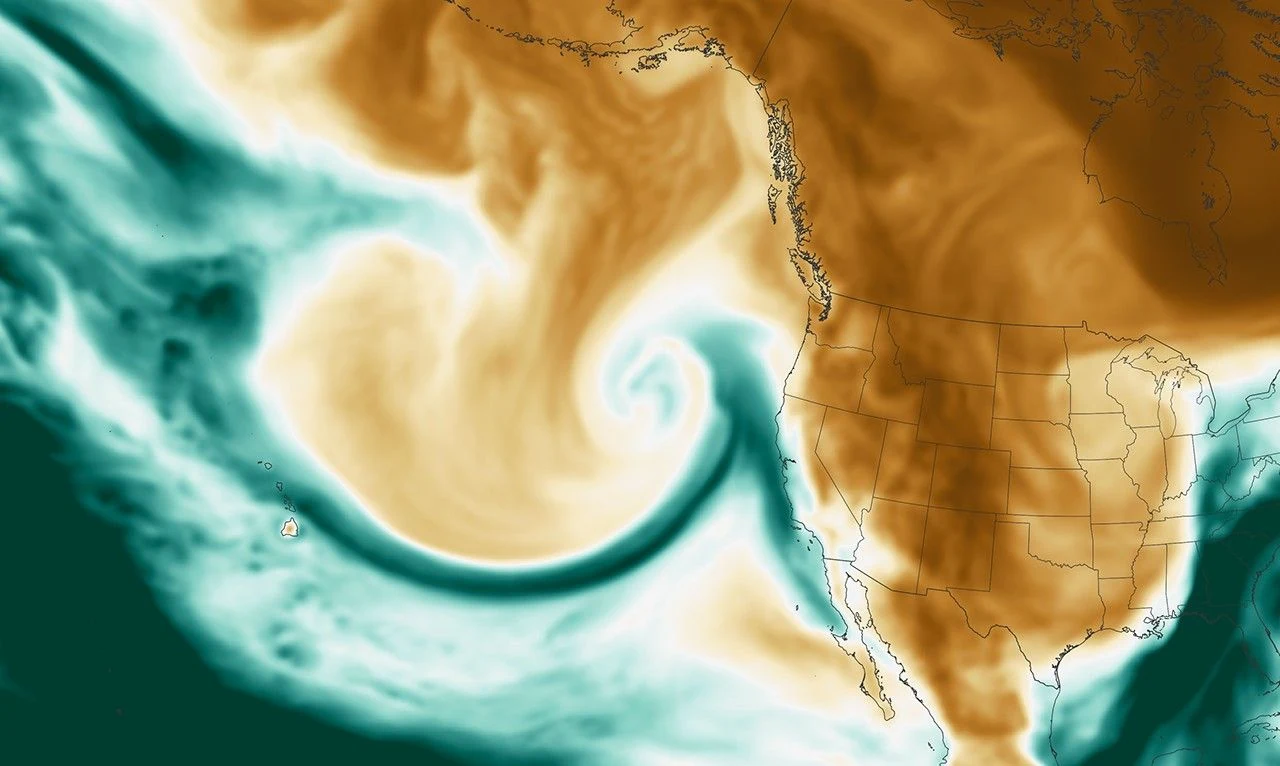
Every Pineapple Express is an atmospheric river, but most atmospheric rivers are not a Pineapple Express. Plenty of them tap moisture from farther north or west in the Pacific. The distinction matters for one practical reason: air from near Hawaii is warm, so a Pineapple Express tends to push the snow level high into the mountains. More of the precipitation falls as rain, and rain landing on an existing snowpack can send a surge of meltwater downstream on top of the storm itself.
The AR Scale: Rating an Atmospheric River from 1 to 5
In 2019, a team led by F. Martin Ralph at the Scripps Institution of Oceanography, working with the National Weather Service, published a scale for atmospheric rivers in the Bulletin of the American Meteorological Society. It rates a storm at a given location from AR 1 to AR 5, and it is built on two things.
Strength is measured as integrated water vapor transport (IVT): how much water vapor is moving past a point through the full depth of the atmosphere, in kilograms per meter per second. Atmospheric river conditions begin at an IVT of 250.
Duration is how long those conditions last over one spot. A storm that passes in under 24 hours drops one category. One that lingers past 48 hours moves up one.
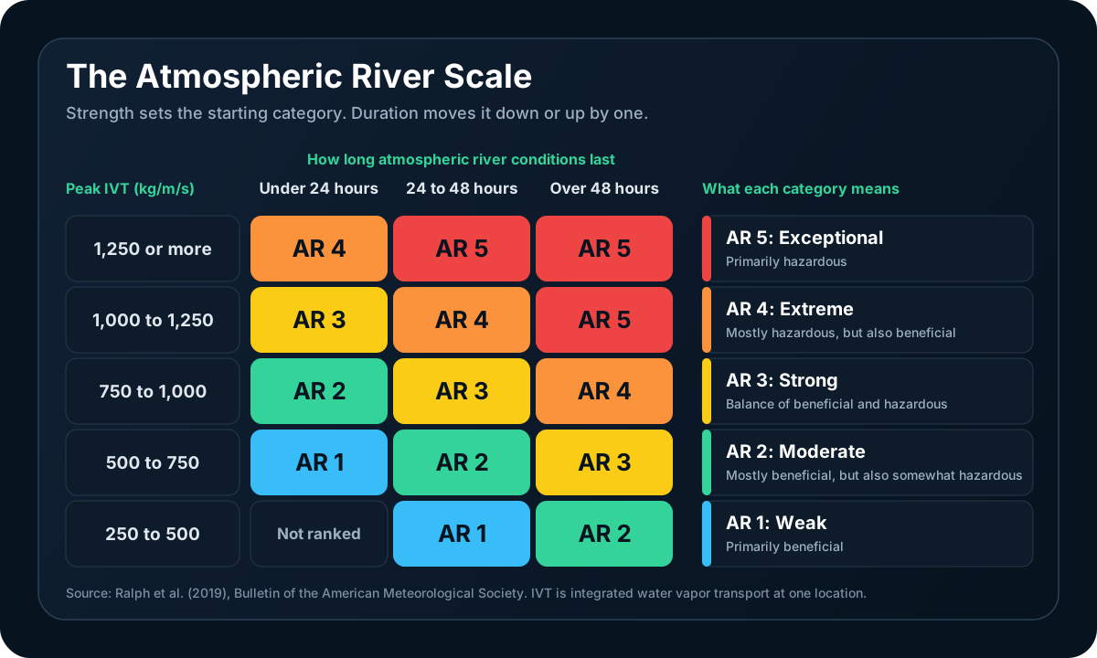
| Category | Name | What It Usually Means |
|---|---|---|
| AR 1 | Weak | Primarily beneficial: light to modest rain and mountain snow |
| AR 2 | Moderate | Mostly beneficial, but also somewhat hazardous |
| AR 3 | Strong | A balance of beneficial and hazardous |
| AR 4 | Extreme | Mostly hazardous, but also beneficial |
| AR 5 | Exceptional | Primarily hazardous: widespread flooding is likely |
The benchmark AR 5 in the original paper ran from 29 December 1996 to 2 January 1997. It lasted more than 100 hours and caused over $1 billion in damage.
Two things make this scale different from the Saffir-Simpson hurricane scale. It counts benefit as well as hazard, because the same storms that flood towns also fill reservoirs. And it is specific to a location: one atmospheric river can be an AR 4 where the core comes ashore and an AR 1 two hundred miles up the coast.
Why Atmospheric Rivers Matter So Much in the West
The West Coast depends on a small number of big storms. Atmospheric rivers deliver 30 to 50% of the West Coast's annual precipitation, according to NOAA. A 2025 Scripps study found the share reaches up to 65% in Northern California and up to 40% in Southern California.
That concentration cuts both ways.
The benefit. A few good atmospheric rivers build the Sierra Nevada and Cascade snowpack, refill reservoirs, and end droughts. In December 2010, a 13-day run of them left the Sierra Nevada with 75% of its annual snow by the 22nd of the month.
The cost. A Scripps-led study in Science Advances examined 40 years of National Flood Insurance Program data across the western states. Atmospheric rivers were responsible for more than 84% of the flood damage, an average of about $1.1 billion a year. Nearly half of the total came from just ten storms.
The hazards go beyond river flooding:
- Flash flooding and urban flooding when intense rain bands stall over one area. See our guide to understanding flash floods.
- Debris flows on slopes burned by recent wildfires, where bare soil cannot absorb heavy rain.
- Landslides and mudslides after days of rain saturate hillsides.
- Damaging wind, since strong atmospheric rivers arrive with strong storms. Saturated soil lets trees topple at lower wind speeds.
- Heavy mountain snow on the cold side of the storm, with multi-foot totals and avalanche danger.
Atmospheric rivers are not only a West Coast story. They make landfall in western Europe, Chile, New Zealand, and elsewhere, and they contribute to heavy rain events in the central and eastern United States as well.
Does El Niño Mean More Atmospheric Rivers?
This is the question of the winter. NOAA expects El Niño to be very strong through the 2026 to 2027 cold season (our El Niño 2026 explainer tracks the current strength and odds as NOAA updates them). So does a powerful El Niño mean a parade of atmospheric rivers?
It shifts the odds. It does not write the schedule.
Here is what El Niño does reliably. It strengthens the Pacific jet stream and extends it east across the southern United States. That pulls the average winter storm track south, which tilts the odds toward a wetter California and Southwest. Storms steered along that southern track have more opportunity to deliver atmospheric rivers to California than they would in a typical year.
Here is what it cannot do: tell you how many atmospheric rivers will form, how strong they will be, or exactly where they will come ashore. Those depend on individual weather patterns that take shape days to weeks ahead, and the history shows how much room that leaves.
| Winter | El Niño or La Niña | What Happened in California |
|---|---|---|
| 2015 to 2016 | One of the strongest El Niños on record | Southern California finished drier than average and the drought continued |
| 2016 to 2017 | Weak La Niña | The wettest water year on record in the northern Sierra Nevada |
| 2022 to 2023 | La Niña | A run of strong atmospheric rivers produced one of the state's wettest years |
A 2025 study from Scripps, published in Climate Dynamics, measured this directly. About a third of El Niño and La Niña years turned out opposite to the expected pattern in California, and atmospheric river activity explained roughly 70% of those surprises. A few powerful storms can turn a La Niña winter wet. Their absence can turn an El Niño winter dry. Scripps climate scientist Alexander Gershunov summed it up in one line: "Atmospheric rivers don't dance to the tune of ENSO."
The winter of 2022 to 2023 adds a useful detail. The West Coast as a whole recorded fewer landfalling atmospheric rivers that year than the year before (46 against 61), yet California had far more impact, because the storm track ran farther south and the storms that arrived were stronger. Track and strength matter more than the count.
What that means for this winter
- The odds favor a more active southern storm track. That raises the chance of impactful atmospheric rivers in California and the Southwest. It is a tilt in probability, and the size of that tilt is what NOAA's seasonal outlooks express.
- The Pacific Northwest is not off the hook. Atmospheric river season there peaks in autumn and early winter, before El Niño's influence on the jet stream is at its strongest, and one strong storm is all it takes.
- Watch the two-week window, not the seasonal headline. Forecasters can often see an atmospheric river taking shape a week or more ahead and can warn of heavy rain and flooding five to seven days out. That is the forecast to act on.
- No one can forecast your season total. Seasonal outlooks give odds for wetter or drier than normal across a region. They do not count storms. The same limit applies to snow, for the reasons covered in why snow total forecasts vary.
How to Spot an Atmospheric River in the Forecast
| Forecast Clue | What It Signals |
|---|---|
| "Atmospheric river" or "AR 3" in a forecast discussion | Forecasters have identified the plume and rated its expected strength |
| A narrow band on an IVT or total precipitable water map | The moisture corridor itself, often stretching back toward Hawaii |
| A long plume on water vapor satellite imagery | The storm system and jet stream pattern steering the river toward the coast |
| "Snow levels rising to 8,000 feet" | A warm storm: rain will fall on mountain snowpack |
| Flood Watch | Flooding is possible. Get ready |
| Flood Warning or Flash Flood Warning | Flooding is happening or about to. Act now |
| WPC Excessive Rainfall Outlook at Moderate or High risk | National forecasters expect rain heavy enough to cause flooding |
| Rivers forecast to reach flood stage | Check the forecast crest and timing for the gauge nearest you |
To see the river itself, look at a map of IVT or total precipitable water, like the NASA map earlier in this post. The Center for Western Weather and Water Extremes publishes IVT forecasts for the West Coast. Water vapor satellite imagery answers a different question. Its channels sense moisture in the middle and upper atmosphere, while an atmospheric river flows mostly in the lowest two miles, so the plume you see on those images can sit apart from where the heaviest low-level moisture is. Use it to follow the storm and the jet stream pattern steering the river. Our guide to reading satellite imagery explains how those channels work.
Staying Safe During an Atmospheric River
- Never drive through floodwater. Twelve inches of moving water can carry away most cars. Turn around and find another route.
- Know if you live below a burn scar. Debris flows can start with little warning during intense rain. If officials order an evacuation, leave early.
- Clear gutters and storm drains before the rain arrives, and move vehicles out of low spots.
- Prepare for power outages. Charge devices, and keep flashlights and a few days of supplies on hand.
- Avoid mountain travel during the peak of the storm. Check chain controls and road closures before you leave.
- Stay away from swollen creeks and rivers. Banks can give way, and the water is faster and colder than it looks.
Always Verify with Official Sources
Every atmospheric river is different, and local terrain changes the outcome from one valley to the next. For decisions that affect your safety, rely on your local National Weather Service office, the Weather Prediction Center, and your county emergency management agency. For atmospheric river forecasts and current AR scale ratings along the West Coast, the Center for Western Weather and Water Extremes at Scripps is the authority.
Frequently Asked Questions
Is an atmospheric river the same as a Pineapple Express?
No. A Pineapple Express is one type of atmospheric river: a strong one whose moisture comes from the tropical Pacific near Hawaii. Atmospheric river is the general term for any long, narrow corridor of water vapor transport, wherever the moisture originates. Many of the atmospheric rivers that reach the West Coast draw on moisture from farther north or west and are not a Pineapple Express.
How long does an atmospheric river last?
At any one location, atmospheric river conditions usually last from under a day to about two days. Storms that stall can last three days or longer, and those are the dangerous ones, because duration is what turns heavy rain into major flooding. That is why the AR scale raises a storm by one category when conditions persist past 48 hours. Atmospheric rivers also tend to arrive in groups, with a new one following every few days, so the ground has no time to drain between them.
Are atmospheric rivers always dangerous?
No. Most are weak, and they deliver rain and mountain snow that the West depends on for its water supply. On the AR scale, AR 1 and AR 2 storms are rated as mainly beneficial. The danger rises with strength and duration: AR 4 and AR 5 storms are rated as mostly or primarily hazardous and account for the bulk of flood damage.
Does El Niño cause more atmospheric rivers?
El Niño does not create atmospheric rivers, and it does not guarantee more of them. It strengthens the Pacific jet stream and shifts the average storm track south, which raises the odds of a wet winter in California and the Southwest. Whether those odds pay off depends on individual storms. The very strong El Niño of 2015 to 2016 left Southern California drier than average, while the La Niña winter of 2022 to 2023 brought a run of powerful atmospheric rivers.
How far ahead can an atmospheric river be forecast?
Forecasters can often identify one about a week ahead and can issue warnings for heavy rain and flooding five to seven days in advance. The exact landfall location and the snow level become clear closer to arrival, usually within two to three days. Researchers at Scripps have found signals as far as three weeks ahead in some cases. The number of atmospheric rivers in a whole season cannot be predicted reliably.
Do atmospheric rivers only hit California?
No. Along the West Coast they affect British Columbia, Washington, and Oregon as much as California, with the most active season arriving earlier in the north (autumn) than in the south (midwinter). They also make landfall in western Europe, Chile, and New Zealand, and they contribute to heavy rain events in the central and eastern United States.
Track Atmospheric Rivers with WeatherAI
WeatherAI puts the tools for following an incoming storm on your iPhone:
- Flood Watches and Warnings from the National Weather Service as push notifications for your saved locations
- Water vapor satellite imagery across the full Pacific on the GOES-18 full disk view, so you can watch the storm system steering the river toward the coast (Pro)
- WPC rainfall outlooks and precipitation discussions as map overlays
- River gauges with observed levels, forecast hydrographs, and flood stages
- AI-powered explanations: ask "How much rain is this storm bringing, and when is the worst of it?" and get a plain-English answer for your location
Download WeatherAI for iPhone →
Sources
- NOAA: What are atmospheric rivers?
- Ralph et al. (2019), A Scale to Characterize the Strength and Impacts of Atmospheric Rivers, Bulletin of the American Meteorological Society
- Corringham et al. (2019), Atmospheric rivers drive flood damages in the western United States, Science Advances
- Luna-Niño et al. (2025), Atmospheric Rivers Explain Atypical El Niño and La Niña Years, Climate Dynamics
- Center for Western Weather and Water Extremes: Water Year 2023 final summary and atmospheric river scale and forecasts
Want to understand more about this winter's weather? Read our El Niño 2026 explainer, our guide to understanding flash floods, and what the polar vortex is.
Keep Reading
These articles cover adjacent weather questions, practical explainers, and planning workflows related to this topic.
Weather Education
El Niño 2026: How Strong It Is, and What It Actually Means
El Niño is strengthening in 2026, with a greater than 90% chance of becoming very strong and 75% odds of exceeding every event since 1950. What that means for hurricane season and winter.
Weather Education
What Is the Polar Vortex? Understanding Extreme Winter Cold
Learn what the polar vortex is, how it affects winter weather across North America, why it sometimes 'breaks down' to deliver extreme cold, and what to expect during polar vortex events.
Weather Education
Understanding Flash Floods: Causes, Warnings, and Safety
Learn what causes flash floods, how to spot the risk on radar, the difference between watches, warnings, and emergencies, and critical safety steps that save lives.
Useful Next Stops
Jump from the explainer into tools, feature pages, and seasonal hubs that deepen the topic.
Guide
Understanding Flash Floods
Learn what causes flash floods, how to spot the risk on radar, and the safety steps that save lives.
Tool
Pressure Tendency Calculator
Calculate 3-hour barometric pressure tendency from rising or falling readings.
Guide
Reading Satellite Imagery
Use GOES and Himawari visible, infrared, and water vapor satellite imagery to spot developing storms and larger weather patterns.
Glossary
Atmospheric River
A long, narrow corridor of concentrated water vapor moving through the lower atmosphere, typically 250 to 375 miles wide and often more than 1,000 miles long.