Winter Storm Watch vs Warning vs Winter Weather Advisory (Plus Blizzard, Ice Storm, and Snow Squall Warnings)
What a Winter Storm Watch, Winter Storm Warning, and Winter Weather Advisory mean, how many inches of snow trigger a warning where you live, and how Blizzard, Ice Storm, Snow Squall, and Extreme Cold Warnings differ.
Quick Answer: Winter Storm Watch vs Warning vs Advisory
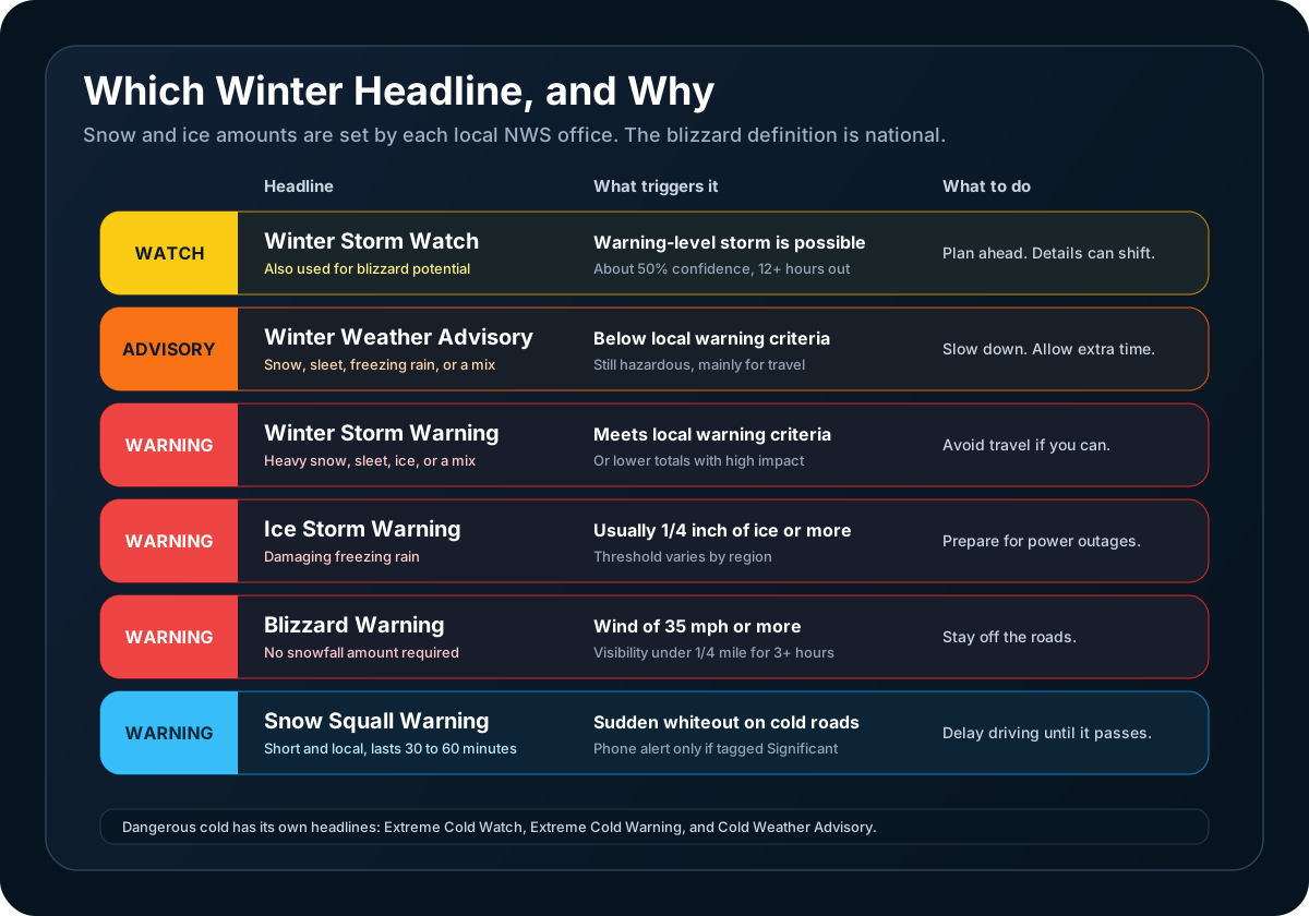
A Winter Storm Watch means a significant winter storm is possible. A Winter Storm Warning means one is expected or under way. A Winter Weather Advisory means winter weather is expected that falls short of warning level but is still hazardous, mostly for travel.
The National Weather Service (NWS) uses a handful of other winter headlines for specific hazards. This is the current set.
| Headline | What it means | What triggers it |
|---|---|---|
| Winter Storm Watch | A warning-level storm is possible | At least 50% confidence that local warning criteria will be met |
| Winter Weather Advisory | Snow, sleet, freezing rain, or blowing snow that is hazardous but below warning level | At least 80% confidence that local advisory criteria will be met |
| Winter Storm Warning | Heavy snow, sleet, ice, or a combination | At least 80% confidence that local warning criteria will be met, or a lesser storm with unusually high impact |
| Blizzard Warning | Whiteout conditions from wind and snow | Sustained wind or frequent gusts of 35 mph or more, with visibility frequently below 1/4 mile, for 3 hours or more |
| Ice Storm Warning | Damaging ice from freezing rain | Ice accumulation at the local warning threshold, usually 1/4 inch or more |
| Lake Effect Snow Warning | Heavy snow in narrow bands downwind of a large lake | Local warning criteria. Used by some offices only |
| Snow Squall Warning | A brief, intense burst of snow and wind | Visibility of 1/4 mile or less on sub-freezing roads, or a flash freeze. Valid 30 to 60 minutes |
| Extreme Cold Watch, Extreme Cold Warning, Cold Weather Advisory | Dangerously cold air or wind chill | Local temperature or wind chill criteria |
The snow and ice amounts behind "local criteria" differ from one forecast office to the next, which is the subject of most of this guide. All of the figures come from the NWS winter weather products specification, which describes its own values as guidance and not strict thresholds.
Watch, Warning, Advisory: Confidence First, Then Severity
The three core headlines answer two different questions.
How confident is the forecast? A Winter Storm Watch is issued when forecasters have at least 50% confidence that a storm will reach local warning criteria. Warnings and advisories are issued at 80% confidence or higher. The specification asks offices to issue each of them with as much lead time as confidence allows, and it gives no fixed number of hours. The one timing rule is at the short end: a watch is not issued within 12 hours of the expected start. By then the office either upgrades it to a warning or advisory, or cancels it.
How serious is it? Once confidence is high, the split between an advisory and a warning is severity. A warning is for conditions that threaten life or property. An advisory is for less serious conditions that cause significant inconvenience and can become dangerous if you do not take care.
That means the advisory is not a step between the watch and the warning. A watch can turn into either one, and an advisory can be issued with no watch before it. Our guide to outlooks, watches, advisories, and warnings covers how the same logic applies across all hazards.
One more thing is built into the system: forecaster judgment. The specification says a warning or advisory may be appropriate for a minor snowfall near rush hour or early in the season, even when amounts fall short of the usual criteria. A Winter Storm Warning for three inches is not necessarily an error. It can be a decision about impact.
Why Six Inches Is a Warning in One City and a Nuisance in Another
There is no national number of inches for a Winter Storm Warning. Each forecast office sets criteria around what its area is equipped for and used to, and the NWS publishes them on a national snow criteria map.
These examples are taken from each office's own published criteria:
| Forecast office | Winter Storm Warning for snow | Winter Weather Advisory for snow |
|---|---|---|
| Atlanta (Peachtree City), GA | 2 inches or more | Enough to cause inconvenience, below warning level |
| Raleigh, NC | 3 inches in 12 hours or 4 inches in 24 hours | 1 inch in 12 hours or 3 inches in 24 hours |
| Twin Cities, MN | 6 inches or more in an event | 3 to less than 6 inches |
| Burlington, VT | 7 inches averaged over a forecast zone | 4 inches averaged over a forecast zone |
| Anchorage, AK office (most zones) | 12 inches in 12 hours or 24 inches in 24 hours | Not listed in the specification |
The Anchorage figures are from the national specification, which lists Alaska's criteria directly. Offices revise these numbers from time to time, so treat the table as an illustration of the range and check the map for your own location.
Two inches is a Winter Storm Warning in Atlanta and below advisory level in Burlington. Both offices are doing the same job: warning when snow will seriously disrupt the people who live there.
How a forecast range becomes a headline
Forecast snowfall is a range, and the headline is decided by the middle of it. The specification uses the midpoint of the forecast range, rounded up to the nearest inch, and compares that to the local criterion.
With a 6-inch warning criterion:
- A forecast of 4 to 8 inches has a midpoint of 6. That is a Winter Storm Warning
- A forecast of 3 to 6 inches has a midpoint of 4.5. That is a Winter Weather Advisory
So a Winter Weather Advisory can sit over a forecast whose top end touches the warning number. For the reasons snow forecasts come as ranges in the first place, see why snow totals vary.
Storm totals, not 12-hour windows
Warnings have often been defined by snow in 12 or 24 hours. The current specification has offices in the contiguous United States use event-based criteria: the total for the storm, with an event generally not running past 48 hours. Some office pages still show 12-hour and 24-hour figures, which is another reason to use the national map as the reference.
Blizzard Warning: It Is About Wind and Visibility
A blizzard is not defined by how much snow falls. The NWS definition has three parts, all of which have to last for three consecutive hours or more:
- Wind: sustained wind or frequent gusts of 35 mph or greater
- Visibility: frequently reduced below 1/4 mile
- Cause: falling snow, blowing snow, or both
There is no snowfall requirement and no temperature requirement. The specification states that blizzard conditions do not require snow to be falling at all. Strong wind lifting snow that is already on the ground can produce a blizzard under a clear sky, often called a ground blizzard.
It works the other way too. Two feet of snow with light wind is a major winter storm and not a blizzard.
Two details about how the warning is used:
- There is no Blizzard Watch. It was folded into the Winter Storm Watch in October 2017. When blizzard conditions are the concern, the watch text begins with the phrase "Blizzard conditions possible"
- A Winter Storm Warning can be upgraded. If wind and visibility are expected to reach blizzard criteria, the office replaces the Winter Storm Warning with a Blizzard Warning for the affected area
The NWS notes that the danger rises sharply when a blizzard combines with temperatures below 20°F, because anyone stranded is then exposed to wind, cold, and no visibility at once.
Ice Storm Warning and Freezing Rain Products
An Ice Storm Warning is issued when freezing rain is expected to leave a damaging accumulation of ice. The NWS describes significant accumulations as usually 1/4 inch or greater, enough to pull down tree limbs and utility lines.
Like snow, the threshold is local. The specification allows higher thresholds where ice is common and lower ones where small amounts cause major problems:
- Most of the country uses 1/4 inch
- Burlington, Vermont uses 1/2 inch, as does much of the Northeast
- The national criteria map shows thresholds below 1/4 inch in parts of Florida, south Texas, and the desert Southwest
The amount refers to flat ice on an elevated horizontal surface, which is how the NWS measures ice. It is not the thickness of the coating around a branch or wire.
For freezing rain below the warning threshold, the headline is a Winter Weather Advisory. There used to be a separate Freezing Rain Advisory. It was merged into the Winter Weather Advisory in October 2017, and an advisory issued only for ice now begins with "Freezing rain expected." Even small amounts of freezing rain can cause significant travel problems, so an advisory for ice is worth taking seriously.
When a storm brings both heavy snow and significant ice, the office usually issues a Winter Storm Warning to cover the combination. Our guide to ice storms, freezing rain, and sleet explains how each type of precipitation forms.
How Lake Effect Snow Is Handled
Lake effect snow has had its own headlines, and most of them are gone. The same October 2017 change merged the Lake Effect Snow Advisory into the Winter Weather Advisory and the Lake Effect Snow Watch into the Winter Storm Watch.
The Lake Effect Snow Warning still exists, but only where a region chooses to use it. Other offices issue a Winter Storm Warning that begins with "Heavy lake effect snow expected." Either way, the text tells you it is lake effect, and that matters because the snow falls in narrow bands, with heavy snow in one place and dry weather a few miles away. See lake effect snow explained for how the bands form and why they are hard to pin down.
Snow Squall Warning, the One That Arrives on Your Phone
A snow squall is a short, intense burst of heavy snow and gusty wind, often along a strong cold front. It passes quickly, leaves little snow, and can turn a clear highway into a whiteout on a suddenly icy surface within minutes.
A Snow Squall Warning is built differently from every other winter headline. It works like a tornado or severe thunderstorm warning:
- It covers a small area drawn around the squall, not whole forecast zones
- It is valid for 30 to 60 minutes
- It is issued when a squall is producing, or is about to produce, visibility of 1/4 mile or less in snow on sub-freezing roads, or a rapid temperature drop that flash-freezes wet pavement along with a significant drop in visibility
Why your phone may or may not sound
Snow Squall Warnings are on the short list of NWS warnings that can trigger a Wireless Emergency Alert, the loud government alert that arrives without any app. Winter Storm, Blizzard, and Ice Storm Warnings are not on that list.
Not every Snow Squall Warning triggers one. Each warning carries an impact tag:
- General (no tag): the more common case, for squalls where the circumstances reduce the threat to travel
- Significant: reserved for squalls that pose a substantial threat to safe travel. Only this tag triggers a Wireless Emergency Alert
Until a few years ago every Snow Squall Warning set off phones. The NWS changed that so the alert is kept for high-impact squalls, and all forecast offices have used the tags since the winter of 2023 to 2024. Each warning also says whether the squall is radar indicated or observed.
What to do
The NWS advice is short: avoid or delay driving until the squall passes, because there is no safe place on a highway during one. If you are already on the road, slow down, turn on headlights and hazard lights, leave extra following distance, and avoid braking hard.
Snow Squall Warnings are not issued while a Winter Storm Warning or Blizzard Warning is already in effect. They can be issued during a Winter Weather Advisory.
Extreme Cold Replaced Wind Chill in 2024
If you are looking for a Wind Chill Warning, it no longer exists. On October 1, 2024, the NWS renamed its cold products:
| Before October 2024 | Now |
|---|---|
| Wind Chill Watch | Extreme Cold Watch |
| Wind Chill Warning | Extreme Cold Warning |
| Wind Chill Advisory | Cold Weather Advisory |
The reasoning is that cold is dangerous with or without wind. The new products can be issued for the air temperature alone or for the wind chill, whichever reaches the local criteria. Wind chill is still calculated and still forecast. It just no longer has its own headline. Our guide to feels-like temperature explains how wind chill is worked out.
Criteria are local here as well, and the spread is wide:
| Forecast office | Cold Weather Advisory | Extreme Cold Warning |
|---|---|---|
| New Orleans, LA (near the coast) | Below 25°F | Below 15°F |
| Raleigh, NC | 5 to 10°F | 0 to -5°F or colder |
| Burlington, VT | -20 to -29°F | -30°F or colder |
| Twin Cities, MN (metro) | Not listed | Colder than -35°F |
Each figure is the temperature or wind chill, whichever is lower. The same change folded the Hard Freeze Warning into the Freeze Warning, which is covered in Frost Advisory vs Freeze Warning.
Frequently Asked Questions
How many inches of snow for a Winter Storm Warning?
It depends on where you are. Each NWS forecast office sets its own criteria, and they range from about 2 inches in parts of the South to 6 or 7 inches at many northern offices and a foot or more in parts of Alaska. Offices can also issue a warning for less when the timing makes the impact unusually high. The NWS snow criteria map shows the number for your location.
What is the difference between a Winter Storm Watch and a Winter Storm Warning?
A Winter Storm Watch means a warning-level storm is possible, with at least 50% confidence, but the track, timing, or amounts are still uncertain. A Winter Storm Warning means forecasters are at least 80% confident the storm will reach local warning criteria, or it is already happening. A watch is the time to plan. A warning is the time to finish preparing and avoid travel.
What does a Winter Weather Advisory mean?
A Winter Weather Advisory means snow, sleet, freezing rain, blowing snow, or a mix is expected at a level below local warning criteria. It is issued with the same high confidence as a warning. The conditions are less serious, but they still make travel hazardous, and an advisory for freezing rain can mean very slick roads from a small amount of ice.
Does a blizzard require heavy snow?
No. A Blizzard Warning requires sustained wind or frequent gusts of 35 mph or more and visibility frequently below 1/4 mile, lasting 3 hours or more. The snow reducing visibility can be falling, blowing, or both, and no accumulation is required. Wind lifting snow already on the ground can create blizzard conditions with nothing falling.
What is a Snow Squall Warning, and why did my phone alert?
A Snow Squall Warning is a short warning, valid for 30 to 60 minutes, for a brief burst of heavy snow and wind that causes sudden whiteouts and icy roads. Your phone sounds only when the warning carries the Significant impact tag, which sends it out as a Wireless Emergency Alert to phones in the warned area. The safest response is to delay driving until it passes.
What happened to Wind Chill Warnings?
The NWS replaced them on October 1, 2024. The Wind Chill Warning became the Extreme Cold Warning, the Wind Chill Watch became the Extreme Cold Watch, and the Wind Chill Advisory became the Cold Weather Advisory. The new products cover dangerous cold whether or not wind is involved. Wind chill is still part of the forecast.
Follow Winter Storms in WeatherAI
WeatherAI shows official NWS winter alerts in full, so you can read the amounts, timing, and wording that set one headline apart from another.
- Official alerts on the map. Alert areas are drawn on the map where the NWS supplies them, which shows whether you are inside a warning or just outside it
- Alerts for the places you care about. Notifications for official alerts are free for your current location plus up to 10 other places you choose
- The forecaster's reasoning. The NWS hub is free and includes your local office's Area Forecast Discussion and Hazardous Weather Outlook, with plain-language summaries on devices with Apple Intelligence
- National winter guidance. Winter weather guidance and discussions from the Weather Prediction Center, the NWS center that forecasts heavy snow and ice nationally
- Snow probability by day. WeatherAI Forecast includes a daily snow probability alongside the hourly and daily forecast
Download WeatherAI for iPhone →
Related: the winter weather hub, NWS Outlook vs Watch vs Advisory vs Warning, and Frost Advisory vs Freeze Warning.
Sources: NWS Instruction 10-513, WFO Winter Weather Products Specification (November 2024), for watch, warning, advisory, blizzard, ice storm, lake effect, and snow squall criteria; NWS Instruction 10-515, WFO Non-Precipitation Weather Products Specification, for the Extreme Cold and Cold Weather products; NWS on the 2017 winter headline consolidation and the 2024 cold product changes; NWS snow squall safety and impact-based Snow Squall Warnings; NWS Wireless Emergency Alerts. Local criteria are from the office pages linked in the tables. Criteria vary by office and change over time, so confirm them with your local NWS office.
Keep Reading
These articles cover adjacent weather questions, practical explainers, and planning workflows related to this topic.
Weather Education
Frost Advisory vs Freeze Warning vs Hard Freeze: What Each One Means
A Frost Advisory usually means lows of 33 to 36°F, a Freeze Warning 32°F or colder, and a hard freeze about 28°F or colder. Learn why frost forms above freezing, why the alerts stop in late fall, and what to protect at each level.
Weather Education
Understanding Snow Totals: Why Forecasts Vary
Learn why snow forecasts give ranges instead of exact numbers. Understand snow ratios, banding, elevation effects, and how to interpret winter storm predictions.
Weather News
Archived: January 2026 Eastern US Winter Storm Forecast
Corrected archive of January 22, 2026 winter storm coverage, with a dated government outlook and links to post-event reports. Not a current forecast.
Useful Next Stops
Jump from the explainer into tools, feature pages, and seasonal hubs that deepen the topic.
Seasonal Hub
Winter Weather Guide
Find practical explainers on snow, freezing rain, wind chill, and winter travel risk.
Guide
Ice Storm vs Freezing Rain vs Sleet
The key differences between winter precipitation types, how each forms, and how to stay safe.
Tool
Wind Chill Calculator
Estimate cold-weather exposure risk from temperature and wind speed.
Glossary
Blizzard
A blizzard is a storm with sustained winds or frequent gusts of 35 mph or more and falling or blowing snow that frequently reduces visibility to below a quarter mile, lasting 3 hours or longer.