Lake Effect Snow: Why One Town Gets Three Feet and the Next Gets Flurries
What lake effect snow is, how it forms, why Buffalo gets so much of it, why totals change within a few miles, and what a Lake Effect Snow Warning means today.
Quick Answer: What Is Lake Effect Snow?
Lake effect snow forms when cold, dry air blows across a large lake that is warmer than the air and not frozen. The lake adds heat and moisture to the bottom of the air mass. That air rises, builds into clouds, and drops its moisture as snow on the downwind shore, usually in narrow bands.
| Feature | What to Know |
|---|---|
| Main ingredient | A lake at least 13°C (about 23°F) warmer than the air roughly 5,000 feet above it |
| Fetch needed | Enough open water under the wind to load the air (on the Great Lakes, forecasters look for about 40 miles or more) |
| Shape | Narrow bands that can sit over the same towns for a day or more |
| Snowfall rate | Often 2 to 3 inches per hour, and 6 to 7 inches per hour has been measured in the most intense bands |
| Peak season | Mid-November to mid-February downwind of Lakes Erie and Ontario |
| Alert to watch for | Lake Effect Snow Warning in New York, Pennsylvania, and Ohio; Winter Storm Warning around the western lakes |
If you only remember one thing: with lake effect snow, where the band sits matters more than how strong the storm is. A band a few miles wide can bury one town and leave the next one in sunshine.
The Recipe: How Lake Effect Snow Forms
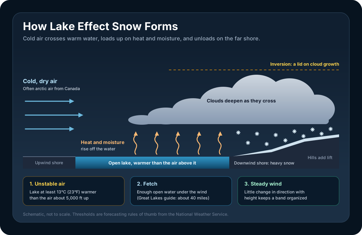
Lake effect snow does not need a storm system. It needs a lake, a cold air mass, and wind that cooperates. Forecasters check a short list of ingredients.
1. A lake much warmer than the air above it
Lakes cool slowly. In late fall the water is still holding summer heat while the first arctic air masses arrive from Canada. The bigger the temperature gap, the faster warm, moist air rises off the surface.
The working rule in National Weather Service forecasting is a gap of at least 13°C (about 23°F) between the lake surface and the air at the 850 millibar level, roughly 5,000 feet up. At that point the air cools with height fast enough that a parcel warmed by the lake keeps rising on its own. Below that gap, pure lake effect is unlikely.
Big events blow past the minimum. During the Buffalo storm of November 2014, Lake Erie was around 9°C (48°F) and the air at 850 millibars was -15°C (5°F), a gap of 24°C.
2. Enough fetch
Fetch is the distance the wind travels over open water. More fetch means more time to load the air with heat and moisture. NWS forecasters in New York look for at least 40 miles on the Great Lakes, a forecasting guideline rather than a hard minimum (smaller lakes produce lighter lake effect snow with far less), and the heaviest bands form when the wind runs the full length of a lake.
3. Wind that lines up
Lake effect bands form parallel to the wind in the layer roughly 2,000 to 5,000 feet above the ground. When the wind holds nearly the same direction through that layer, the band stays narrow, organized, and intense. When the direction turns sharply with height, the band smears out and weakens.
4. Room to grow
A layer of warmer air aloft, called an inversion, acts as a lid on the clouds. A high lid allows deep clouds and heavy snow. A low lid squashes them. In an NWS case study from Lake Champlain, an inversion that dropped to 5,000 feet was one reason a promising setup produced very little.
A passing upper-level disturbance, extra moisture from a lake farther upwind, and hills on the downwind shore all add to the total. Lake Huron and Lake Superior regularly feed bands that end up over New York.
Single Bands vs Multi-Bands
The same lake can produce very different snow depending on how the wind crosses it. The NWS sorts lake effect into a few types, and two of them cover most events.
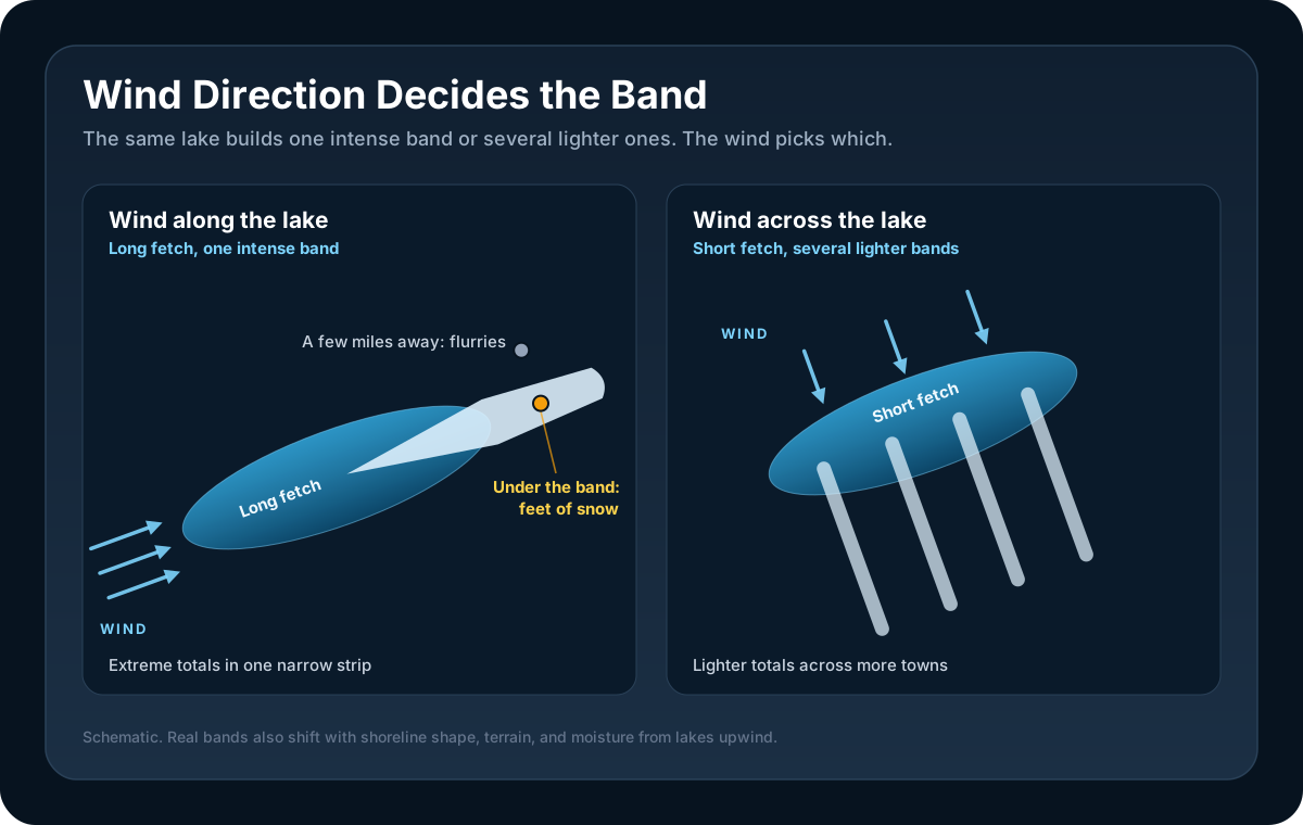
Single bands form when the wind blows down the long axis of a lake. All of that fetch feeds one band, which comes ashore near the far end. These are the events that make the news. Snowfall rates of 6 to 7 inches per hour have been measured in the strongest ones, sometimes with thunder and lightning.
Multi-bands form when the wind crosses the short way. Each band has less water to work with, so the snow is lighter, but several bands line up side by side and cover a longer stretch of shoreline. During a January 2014 event, a single plume of heavy snow off Lake Erie broke into multiple bands, with rates generally under an inch per hour, once the wind began turning more with height and the lid lowered.
A wind shift can flip a lake from one mode to the other within a few hours, which is one reason lake effect forecasts are worded with wide ranges.
Why Totals Change in Five Miles
The storm of 17 to 19 November 2014 is the textbook case. A single band off Lake Erie parked over the southern and eastern suburbs of Buffalo.
| Location | Storm total |
|---|---|
| South Cheektowaga | 65 inches |
| Lancaster | 63 inches |
| West Seneca | 57 inches |
| Hamburg | 48 inches |
| Buffalo airport, a few miles north of the band | 6.2 inches |
The band was only 15 to 20 miles wide, and its northern edge was so sharp that people described it as a wall of snow. Along one road, the NWS found a few inches at one intersection and several feet at another less than 2 miles south.
Three things create gradients like that.
The band is narrow and it stays put. Snow falls at 3 inches per hour or more inside the band and not at all outside it. As long as the wind direction holds, the band does not move. In November 2022, a band dropped 81.2 inches on Hamburg, New York, in about 60 hours.
Small wind shifts swing the band like a gate. The band is anchored to the lake, so a slight change in wind direction moves its far end a long way. A 5 degree shift moves the band about 4 miles sideways at a point 50 miles downwind. That is enough to move the heaviest snow from one town to the next.
Hills squeeze out more. Air forced up rising ground drops more snow. The Tug Hill Plateau, east of Lake Ontario, typically gets more than 200 inches of snow a year, mostly from lake effect.
Depth on the ground also depends on how fluffy the snow is. Our snow-to-liquid ratio calculator shows how the same amount of water can pile up to very different depths, and our guide to why snow total forecasts vary covers the rest of the uncertainty.
Why Does Buffalo Get So Much Snow?
Geography. Lake Erie is about 240 miles long and only 57 miles wide, it runs from southwest to northeast, and Buffalo sits at its northeastern tip. When the wind blows from the southwest, it travels nearly the whole length of the lake before it reaches land, and the band it builds comes ashore over the Buffalo metro area. In the biggest recent storms, the heaviest snow landed just south and east of the city, in suburbs such as Hamburg, Orchard Park, and Lancaster.
The same logic explains the Tug Hill. Lake Ontario runs west to east, so a west wind uses its full length and aims the band at the plateau and the Interstate 81 corridor between Syracuse and Watertown.
Lake Erie has one more quirk. It is the shallowest of the Great Lakes, with an average depth of about 62 feet, and it frequently freezes over in winter. Ice cuts off the supply of heat and moisture, so Buffalo's lake effect season fades once the lake is covered, and the timing varies a lot from year to year. Lake Ontario averages 283 feet deep and gets far less ice, so the snow east of it can continue later into the winter.
Why Radar Can Miss Lake Effect Snow
Lake effect clouds are shallow. Most of the action happens in the lowest several thousand feet of the atmosphere, under that inversion, and only the most extreme events grow much taller.
That is a problem for radar. A radar beam travels in a nearly straight line while the Earth curves away beneath it, so the beam climbs with distance. The lowest NEXRAD scan is typically tilted half a degree above the horizon. About 60 miles from the radar, the center of that lowest beam is already close to a mile above the ground. Our guide to radar beam height walks through the geometry.
At that range the beam can pass over most of a lake effect band, or over all of it. The radar then shows light snow where heavy snow is falling, or shows nothing. NOAA researchers have described shallow lake effect storms as a detection and warning challenge around Buffalo, and a multi-year study at the NWS office in Marquette, Michigan found that shallow snow events are very common there and hard to detect with conventional remote sensing.
What to do about it:
- Know where your radar is. If you are well away from the nearest site, treat a quiet radar with suspicion during a lake effect setup.
- Look upstream. A band that looks strong over the lake or near the radar is probably still strong when it fades from view farther out.
- Check surface observations. Visibility and snowfall reports from nearby stations show what is reaching the ground.
- Read the forecast, not only the radar. The local NWS forecast discussion usually says where forecasters expect the band to set up and when it should move.
The Lake Effect Snow Warning Today
The alert for lake effect snow has changed more than once, so here is where it stands.
- Lake Effect Snow Warning: still issued, but only in some places. The current NWS winter products directive, dated 6 November 2024, lists it as a product used at regional discretion. NWS offices in the Eastern Region, which covers New York, Pennsylvania, and Ohio, issue it. Buffalo, Cleveland, and Binghamton all used it in recent winters.
- Around the western Great Lakes, look for a Winter Storm Warning. Offices in Michigan, Indiana, Illinois, Wisconsin, and Minnesota issue a Winter Storm Warning for heavy lake effect snow, with wording such as "heavy lake effect snow expected."
- There is no Lake Effect Snow Watch or Advisory anymore. Both were folded into broader products on 1 October 2017. Lake effect snow that might reach warning levels gets a Winter Storm Watch. Lighter lake effect snow gets a Winter Weather Advisory.
The Lake Effect Snow Warning itself was briefly retired everywhere for the winter of 2018 to 2019, then brought back in the Eastern Region the following season.
Criteria are local. In upstate New York, a Lake Effect Snow Warning means 7 inches or more in 12 hours, or 9 inches or more in 24 hours. Our guide to winter storm watches, warnings, and advisories explains how the three levels fit together.
When a warning is issued for your area:
- Stay off the roads if you can. Visibility inside a band can drop to near zero without warning, and conditions can go from dry to heavy snow within a few miles.
- If you must drive, slow down, leave extra following distance, and carry warm clothes and an emergency kit.
- If you get stranded, stay in your vehicle. The NWS advises running the engine about 10 minutes each hour for heat and keeping the exhaust pipe clear of snow to prevent carbon monoxide poisoning.
- Clear furnace and dryer vents at home when snow piles up fast.
Beyond the Great Lakes
Any body of water that is big enough, warm enough, and unfrozen can do this.
The Great Salt Lake. Lake effect bands form here in cold northwest flow behind a front and reach into the Salt Lake City metro area. The lake is so salty that it rarely freezes, which keeps it available all winter. NWS forecasters in Salt Lake City use a slightly different yardstick, looking for the lake to be at least 16°C warmer than the air at 700 millibars, a level higher up than the one used around the Great Lakes. A storm in October 1984 produced more than two feet of snow in the Salt Lake City area, and bands that reach the Wasatch Mountains get a further boost from the terrain.
Bays and the ocean. The same process over salt water is called bay effect or ocean effect snow. NWS forecasters in Virginia have documented Chesapeake Bay effect snow in the Norfolk area when a north wind blows down the length of the bay, and they apply the same 13°C rule.
Smaller lakes. Lake Champlain produces lake effect snow in Vermont when the wind follows its long axis. Even the small lakes around Madison, Wisconsin have produced it with a strong enough temperature contrast.
The Sea of Japan. A far larger version works the same way. Frigid air from Siberia crosses the relatively warm Sea of Japan and unloads on Japan's snow country. Sapporo averages nearly 6 meters (20 feet) of snow a year.
Frequently Asked Questions
What is lake effect snow?
Lake effect snow is snow produced when cold, dry air moves across a large, warmer, unfrozen lake and picks up heat and moisture from the water. The warmed air rises, forms clouds, and drops snow on the downwind shore. It usually falls in narrow bands, so totals vary sharply from one town to the next.
How does lake effect snow form?
Three things have to line up. The lake has to be much warmer than the air above it, with a gap of at least 13°C between the water and the air about 5,000 feet up. The wind has to cross enough open water. On the Great Lakes, forecasters look for about 40 miles or more, though smaller lakes can produce lighter snow with less. And the wind direction has to stay fairly constant with height so the snow organizes into a band. Hills on the downwind shore add to the totals.
Why does Buffalo get so much snow?
Buffalo sits at the northeastern end of Lake Erie, which is about 240 miles long and runs southwest to northeast. A southwest wind travels nearly the full length of the lake, picking up heat and moisture the whole way, and the band it builds comes ashore over the Buffalo area. In November 2022 a single band put 81.2 inches on Hamburg, just south of the city.
What is a Lake Effect Snow Warning?
A Lake Effect Snow Warning is a National Weather Service alert for heavy lake effect snow that meets local warning criteria. It is issued by offices in New York, Pennsylvania, and Ohio. In upstate New York the threshold is 7 inches in 12 hours or 9 inches in 24 hours. Around the western Great Lakes, the same hazard is covered by a Winter Storm Warning.
How much snow can lake effect produce?
Rates of 2 to 3 inches per hour are common inside a band, and 6 to 7 inches per hour has been measured in the most intense events. Because a band can sit over one area for a day or more, totals reach several feet. The November 2014 storm near Buffalo left 65 inches in South Cheektowaga while the airport a few miles north recorded 6.2 inches.
Does lake effect snow stop when the lake freezes?
Mostly, yes. Ice cuts off the heat and moisture that power the bands. Lake Erie is shallow and frequently freezes over in winter, which shuts down most lake effect snow around Buffalo. Lake Ontario gets far less ice, so lake effect snow east of it can continue later into the winter.
Can lake effect snow happen away from the Great Lakes?
Yes. The Great Salt Lake produces lake effect snow in the Salt Lake City area, Chesapeake Bay produces bay effect snow in southeastern Virginia, and Lake Champlain produces it in Vermont. A far larger version happens in Japan, where cold air from Siberia crosses the Sea of Japan.
Why does lake effect snow not always show up on radar?
Lake effect clouds are shallow, often only a few thousand feet deep. A radar beam rises with distance from the radar, so far from the site it can pass over the top of the band. The radar then shows lighter snow than is falling, or nothing. Surface observations and the local forecast discussion fill the gap.
Follow Lake Effect Snow with WeatherAI
WeatherAI puts the tools for tracking a band on your iPhone:
- Official NWS alerts, free. Winter alerts arrive as push notifications for your current location and up to 10 saved locations, under whichever name your local office uses.
- NEXRAD Level 3 and MRMS radar (Pro). Watch where the band is setting up, with the limits of beam height in mind.
- The NWS hub, free. Read your local office's Area Forecast Discussion for the forecasters' reasoning on band placement, and check nearby station observations for what is reaching the ground.
Download WeatherAI for iPhone →
Sources
- National Weather Service: What is lake effect snow? and the New York winter preparedness briefing on lake effect snow (fetch, band types, snowfall rates, seasonality, warning criteria)
- NWS Buffalo event summaries: 17 to 19 November 2014 and 6 to 9 January 2014; NWS Binghamton: winter weather awareness (Tug Hill snowfall)
- U.S. EPA: Great Lakes dimensions and Lake Erie
- NOAA National Severe Storms Laboratory: winter weather research (radar detection of shallow lake effect storms)
- NWS Eastern Region Technical Attachment 2000-05: Lake Effect and Lake Enhanced Snow in the Champlain Valley of Vermont (the 13°C rule, fetch, inversion height)
- NWS Instruction 10-513, WFO Winter Weather Products Specification, 6 November 2024, and the 2019 to 2020 winter partners briefing
- NWS Cleveland: winter product changes of 1 October 2017
- NWS Salt Lake City: Forecasting the 31 October 2004 Lake-Effect Snowstorm of the Great Salt Lake
- NWS Wakefield: Chesapeake Bay effect snow, 25 December 1999; NWS Milwaukee: lake effect snow from the Madison lakes
- Kulie et al. (2021), Snowfall in the Northern Great Lakes: Lessons Learned from a Multisensor Observatory, Bulletin of the American Meteorological Society
- NASA Earth Observatory: Winter Grips Japan
More winter reading: frost advisories and freeze warnings, ice storms, freezing rain, and sleet, the lake effect snow glossary entry, and our winter weather guide.
Keep Reading
These articles cover adjacent weather questions, practical explainers, and planning workflows related to this topic.
Weather Education
Winter Storm Watch vs Warning vs Winter Weather Advisory (Plus Blizzard, Ice Storm, and Snow Squall Warnings)
What a Winter Storm Watch, Winter Storm Warning, and Winter Weather Advisory mean, how many inches of snow trigger a warning where you live, and how Blizzard, Ice Storm, Snow Squall, and Extreme Cold Warnings differ.
Weather Education
Understanding Snow Totals: Why Forecasts Vary
Learn why snow forecasts give ranges instead of exact numbers. Understand snow ratios, banding, elevation effects, and how to interpret winter storm predictions.
Weather Education
Understanding Flash Floods: Causes, Warnings, and Safety
Learn what causes flash floods, how to spot the risk on radar, the difference between watches, warnings, and emergencies, and critical safety steps that save lives.
Useful Next Stops
Jump from the explainer into tools, feature pages, and seasonal hubs that deepen the topic.
Guide
Understanding Snow Totals
Why snow forecasts give ranges instead of exact numbers: snow ratios, banding, and elevation effects.
Seasonal Hub
Winter Weather Guide
Find practical explainers on snow, freezing rain, wind chill, and winter travel risk.
Feature
Professional Radar
Explore high-resolution radar, premium lightning, and satellite layers built for serious weather tracking.
Glossary
Lake Effect Snow
Intense, localized snowfall produced when cold air moves across relatively warm lake water, picking up moisture and heat.