Frost Advisory vs Freeze Warning vs Hard Freeze: What Each One Means
A Frost Advisory usually means lows of 33 to 36°F, a Freeze Warning 32°F or colder, and a hard freeze about 28°F or colder. Learn why frost forms above freezing, why the alerts stop in late fall, and what to protect at each level.
Quick Answer: Frost Advisory vs Freeze Warning vs Hard Freeze
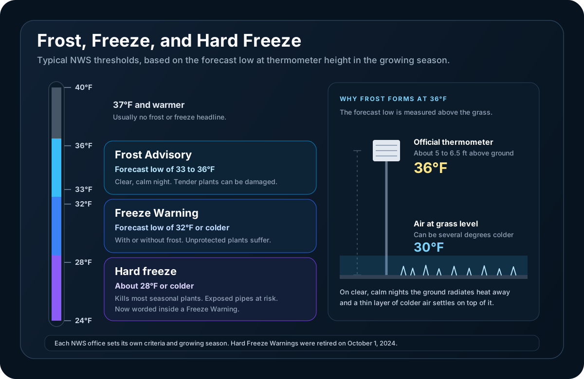
A Frost Advisory means frost is expected while the forecast low stays a little above freezing, typically 33 to 36°F. A Freeze Warning means the air temperature itself is forecast to reach 32°F or colder. A hard freeze is a deeper freeze, about 28°F or colder for a few hours, that kills most seasonal vegetation.
| Headline | Typical forecast low | What it means |
|---|---|---|
| Frost Advisory | 33 to 36°F on a clear, calm night | Frost is likely on plants and other surfaces. Tender plants can be damaged |
| Freeze Watch | 32°F or colder is possible in the next 12 to 48 hours | A freeze may be coming, but timing or coverage is still uncertain |
| Freeze Warning | 32°F or colder | A freeze is expected, with or without visible frost. Unprotected sensitive plants are likely to be damaged |
| Hard freeze (wording inside a Freeze Warning) | About 28°F or colder | Most seasonal vegetation is killed. Unprotected outdoor plumbing can be damaged |
Two caveats apply to every row.
The numbers are typical, not universal. They come from the National Weather Service's national product specification, which calls its criteria guidance rather than strict thresholds. Each forecast office adapts them. The Charleston, West Virginia office, for example, describes its Freeze Warning range as 29 to 32°F. The New Orleans office issues a Freeze Warning every time 32°F is expected along and south of Interstate 10, but north of there only for the first two freezes of the season or after an unseasonably warm spell.
All of them are growing-season products. A Frost Advisory or Freeze Warning exists to protect vegetation, so offices issue them only during a locally defined growing season. That is why a 25°F night in January usually produces no Freeze Warning at all. More on that below.
The Hard Freeze Warning Was Retired in 2024
If you remember seeing a Hard Freeze Warning and cannot find one now, you are not imagining it. On October 1, 2024, the NWS revised its cold-weather products nationwide. Two of the changes affect frost and freeze season:
- Hard Freeze Watch was folded into Freeze Watch
- Hard Freeze Warning was folded into Freeze Warning
The hard freeze itself did not go away. Forecasters now put it in the body of the Freeze Warning, in a line such as "Hard freeze with temperatures as low as 21 expected." So when a Freeze Warning arrives, read the temperatures in it. A warning for 31°F and a warning for 22°F carry the same headline and very different consequences.
The NWS glossary still defines a hard freeze as a surface air temperature of 28°F or lower for an extended period, cold enough to kill most types of vegetation.
The same 2024 change replaced Wind Chill Watches, Warnings, and Advisories with the Extreme Cold Watch, Extreme Cold Warning, and Cold Weather Advisory. Those cover dangerous cold for people, in any season, and are explained in our guide to winter storm and cold headlines.
Why Frost Forms When the Thermometer Says 36
Frost is ice that forms directly on a surface. For that to happen, the surface has to be at or below 32°F. The forecast low does not measure the surface. It measures the air several feet above it.
The thermometer is not where the plants are
Official temperatures are taken well above the ground. NWS offices describe that height as anywhere from four to five feet to two meters (about six and a half feet). The temperature in your forecast, and the one that decides whether an advisory or warning is issued, is the temperature at that height. The national specification calls it the "shelter temperature."
On most nights the difference between shelter height and the ground is small. On a clear, calm night it is not.
Radiational cooling
After sunset the ground radiates heat upward. Clouds send much of that heat back down, and wind stirs warmer air from above into the air near the surface. Take away both and the ground cools quickly, chilling the thin layer of air resting on it. Cold air is dense, so it stays put and pools in low spots.
The NWS office in La Crosse, Wisconsin puts numbers on it: that surface layer can be up to 10 degrees colder than the air four to five feet up, so an official reading of 36°F can sit above air at 30°F or colder right at the surface. The agency's national frost guidance says the same thing more briefly: because frost comes from radiational cooling, it frequently occurs with a thermometer-level temperature in the mid-30s.
That is the whole reason the Frost Advisory range is 33 to 36°F instead of 32°F.
So can frost form above 32°F?
Yes, if "above 32" refers to the reported air temperature. The leaf, windshield, or roof where the frost appears is at or below freezing even though the thermometer overhead is not. Frost on the grass with a low of 35°F is ordinary. A local study by the La Crosse office found patchy frost possible with lows of 38 to 42°F, areas of frost at 33 to 37°F, and widespread frost or freeze at 32°F and below.
The four things to check
Frost at a given forecast low is more likely when:
- Skies are clear. Cloud cover returns heat to the ground and keeps the surface warmer
- Winds are calm or very light. A steady breeze keeps the air mixed. This is also why a Frost Advisory specifies good radiational cooling conditions
- You are in a low spot. Valleys and hollows collect cold air and frost first
- The dew point is low enough. On clear, calm nights the dew point is a reasonable lower bound for the overnight low. A dew point in the 40s tends to hold temperatures up and produce dew or fog instead. A dew point near or below freezing leaves room for the surface to reach 32°F
When wind or cloud prevents frost but the air mass is simply cold enough to drop below 32°F, that is a freeze. A Freeze Warning is issued for the temperature, whether or not any frost is visible.
Why Alerts Stop After the First Hard Freeze
Frost Advisories and Freeze Warnings are tied to the growing season. Once a freeze has ended it, there is nothing left for the alert to protect, and offices stop issuing them until spring.
What counts as the end of the season is decided locally:
- The Charleston, West Virginia office defines the growing season as running from the average date of the last spring freeze to the average date of the first fall freeze, and notes that after a fall freeze the products are no longer issued until the following spring
- The Raleigh, North Carolina office treats the season as typically March 15 to November 15 and ends it in autumn once lows reach 32°F or colder across half or more of each forecast zone for three or more hours
- The New Orleans office issues a Freeze Warning whenever 32°F is expected on the Mississippi coast and along and south of Interstate 10, all winter
- The Tallahassee, Florida office suspends Freeze Warnings after the first widespread light freeze, usually until March 15, but still issues one for a hard freeze, which it defines as 25°F
So three things can be true at once in late fall: the temperature drops to 27°F, no Freeze Warning is issued, and nothing has gone wrong. The season ended on an earlier night.
This matters in two practical ways.
Do not use the absence of a Freeze Warning as a forecast. After the season ends, check the actual forecast low, especially for pipes, irrigation systems, and anything still growing under cover.
The alerts return in spring. The program starts again when the growing season does, sometimes in stages. In 2026 the Charleston office announced the start of the season for its terrain above 2,500 feet on April 17. A late frost after tender plants are in the ground is the case these alerts are most useful for.
Dangerous cold in the middle of winter is covered by a different set of products, the Cold Weather Advisory and Extreme Cold Warning, which are based on temperature or wind chill and exist to protect people.
What to Protect at Each Level
| Frost Advisory (33 to 36°F) | Freeze Warning (32°F or colder) | Hard freeze (about 28°F or colder) | |
|---|---|---|---|
| Plants | Cover tender annuals and vegetables, or bring containers inside | Cover or bring in anything sensitive. Harvest what will not survive | Expect most seasonal plants to be killed. Protect or move anything you intend to keep |
| Pipes | No action normally needed | Wrap, drain, or drip exposed outdoor pipes | Wrap, drain, or drip exposed outdoor pipes. Drain in-ground sprinkler systems and cover above-ground pipes |
| Pets | Normal precautions | Bring pets in overnight and check outdoor water bowls for ice | Keep pets indoors as much as possible |
Plants
A frost damages tender growth: tomatoes, peppers, basil, squash, and most summer annuals. The Omaha NWS office describes the steps this way: frost brings at least minor damage to plants, a freeze brings significant damage to many unprotected plants, and a hard freeze destroys many types of plants and most seasonal vegetation.
Covers work by trapping heat rising from the soil, so put them on before sunset and let them reach the ground. For container plants, moving them into a garage or against a sheltered wall is usually enough for a frost. Our guide for gardeners covers planning around first and last frost dates.
Pipes
The standard NWS wording in a Freeze Warning addresses plumbing directly: outdoor water pipes should be wrapped, drained, or allowed to drip slowly, and in-ground sprinkler systems should be drained with above-ground pipes covered. The colder and longer the freeze, the greater the risk. The Charleston, West Virginia office notes that a hard freeze can damage unprotected plumbing as well as plants, which is one reason to read the temperatures inside a Freeze Warning and not only the headline.
Pets and people
Frost and freeze headlines are written for vegetation, but the temperatures apply to everything outside. NWS cold-weather messaging asks people to keep pets indoors as much as possible. Outdoor water bowls freeze at these temperatures, and so do the wet surfaces people walk on.
Frost vs Freeze vs Black Ice on Roads
A Frost Advisory or Freeze Warning says nothing about roads. Neither does its absence. They are separate questions with a shared cause: surfaces losing heat overnight.
Frost can form on pavement the same way it forms on grass, and it forms first on bridges and overpasses. The NWS notes that bridges and overpasses are particularly dangerous because they freeze before other surfaces. Cold air reaches them from above and below, and there is no ground underneath holding heat.
A freeze matters on roads when there is water to freeze. Dry pavement at 28°F is just cold pavement. Wet pavement at 28°F is ice.
Black ice is the result. The NWS defines it as patchy ice on roadways or other transportation surfaces that cannot easily be seen, often clear, with the black road surface visible underneath. It is most common in the early morning, especially after melted snow refreezes overnight, and it also forms when roads are wet from rain and temperatures then fall below freezing.
The practical reading for a cold, clear morning:
- A frost or freeze headline plus a dry previous day: watch bridges, overpasses, and shaded stretches
- A freeze following rain, drizzle, fog, or snowmelt: treat any wet-looking pavement as ice
- No headline because the growing season has ended: the road risk is unchanged, so check the overnight low yourself
When forecasters expect black ice but conditions do not call for a winter weather headline, they often flag it in a Special Weather Statement. Our guide to outlooks, watches, advisories, and warnings explains where those statements fit. For snow and ice headlines, see the winter weather hub.
Frequently Asked Questions
What temperature is a Freeze Warning?
A Freeze Warning is typically issued when the forecast low is 32°F or colder during the local growing season. That figure is national guidance and offices can adjust it, so some describe the range as 29 to 32°F and add hard freeze wording at about 28°F and below. It is based on the air temperature at thermometer height, and it does not require frost to form.
What temperature is a Frost Advisory?
A Frost Advisory is typically issued for forecast lows of 33 to 36°F during the growing season, on nights with good radiational cooling: clear skies and light winds. The air at thermometer height stays above freezing, but plants and other surfaces near the ground cool to 32°F or below.
Can frost form above 32°F?
Yes. Frost needs the surface to be at or below 32°F, not the air several feet up where the official temperature is measured. On clear, calm nights the ground and the air touching it can be several degrees colder than the reported low, so frost is common with lows in the mid-30s.
What temperature is a hard freeze?
A hard freeze is generally 28°F or colder for at least a few hours. The NWS glossary describes it as cold enough to kill most types of vegetation. The definition varies by office, and the Tallahassee, Florida office, for one, uses 25°F. Since October 1, 2024 there is no separate Hard Freeze Warning. The term appears in the text of a Freeze Warning when temperatures that low are expected.
Is a Frost Advisory or a Freeze Warning worse?
A Freeze Warning is the more serious of the two. A frost mainly damages tender plants and can often be handled with a cover. A freeze damages many unprotected plants outright, and a hard freeze kills most seasonal vegetation and can damage exposed outdoor plumbing.
Why was there no Freeze Warning when it dropped below freezing?
Most likely because the growing season had already ended for your area. Frost and freeze headlines protect vegetation, so offices stop issuing them after a season-ending freeze and resume in spring. Some offices also limit warnings to the first freezes of the season. Outside the growing season, rely on the forecast low itself.
Frost and Freeze Alerts in WeatherAI
Frost Advisories, Freeze Watches, and Freeze Warnings are official NWS alerts, and WeatherAI shows them with the full text, including the expected temperatures and any hard freeze wording.
- Alerts for the places you care about. Notifications for official NWS alerts are free for your current location plus up to 10 other places you choose, which covers a garden across town or a relative's house in another state
- Your own temperature threshold. With Standard or Pro, a custom rule checks the temperature against a threshold you set, at the time of day you pick, for the location you choose
- The numbers behind the frost forecast. The forecast shows the overnight low alongside dew point, wind, and cloud cover, the conditions that decide whether frost forms
- A direct answer. Ask the chat "Will it frost tonight?" and get a reply for your location
Download WeatherAI for iPhone →
Related: NWS Outlook vs Watch vs Advisory vs Warning, Winter Storm Watch vs Warning vs Advisory, and Dew Point vs Humidity.
Sources: NWS Instruction 10-515, WFO Non-Precipitation Weather Products Specification (Frost Advisory, Freeze Watch, and Freeze Warning criteria); NWS on the October 2024 cold product changes; NWS glossary definitions of freeze and hard freeze; NWS frost and black ice safety guidance; NWS La Crosse on what causes frost; local criteria from NWS Charleston WV, Raleigh, New Orleans, Tallahassee, and Omaha. Criteria vary by office and can change, so check your local NWS office for the thresholds that apply to you.
Keep Reading
These articles cover adjacent weather questions, practical explainers, and planning workflows related to this topic.
Weather Education
Winter Storm Watch vs Warning vs Winter Weather Advisory (Plus Blizzard, Ice Storm, and Snow Squall Warnings)
What a Winter Storm Watch, Winter Storm Warning, and Winter Weather Advisory mean, how many inches of snow trigger a warning where you live, and how Blizzard, Ice Storm, Snow Squall, and Extreme Cold Warnings differ.
Weather Education
Watch vs Warning vs Advisory vs Outlook: NWS Weather Alerts Explained
Learn the difference between a weather watch, warning, advisory, and outlook, what a Special Weather Statement means, and when to prepare versus take immediate action.
Weather Education
What Does 'Feels Like' Temperature Mean? Wind Chill vs Feels Like Explained
What feels-like temperature means, how wind chill and heat index differ, the frostbite times on the NWS chart, and why Extreme Cold Warnings replaced the Wind Chill Warning.
Useful Next Stops
Jump from the explainer into tools, feature pages, and seasonal hubs that deepen the topic.
Use Case
Weather App for Gardeners
Track frost risk, rainfall, and growing conditions for planting, watering, and harvest decisions.
Tool
Wind Chill Calculator
Estimate cold-weather exposure risk from temperature and wind speed.
Seasonal Hub
Winter Weather Guide
Find practical explainers on snow, freezing rain, wind chill, and winter travel risk.
Glossary
Frost
Frost is a thin layer of ice crystals that forms on surfaces when they cool to 32°F (0°C) or below and water vapor in the air freezes onto them.