WeatherAI 2025.12.1: Pro Radar, Satellite Imagery, and More
Our biggest update yet brings professional-grade NEXRAD radar, GOES satellite imagery, enhanced MRMS layers, space weather visuals, and dozens of improvements.
A Major Leap Forward
WeatherAI 2025.12.1 is our most substantial update to date. We've added professional-grade radar products, satellite imagery from GOES satellites, expanded space weather capabilities, and refined the experience throughout the app.
The release will be rolling out over the next several days.
Here's everything that's new.
Pro Radar: Professional-Grade NEXRAD Data
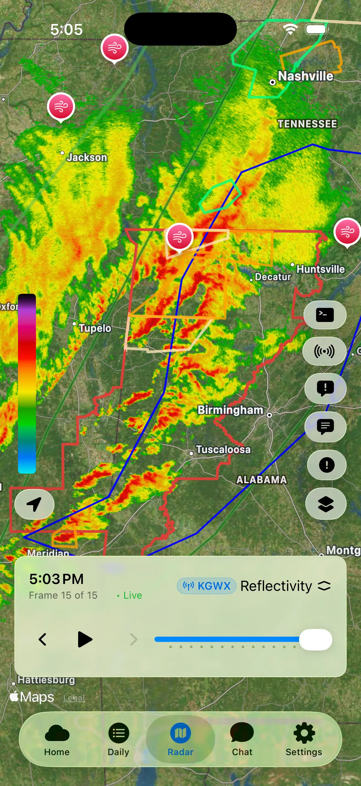
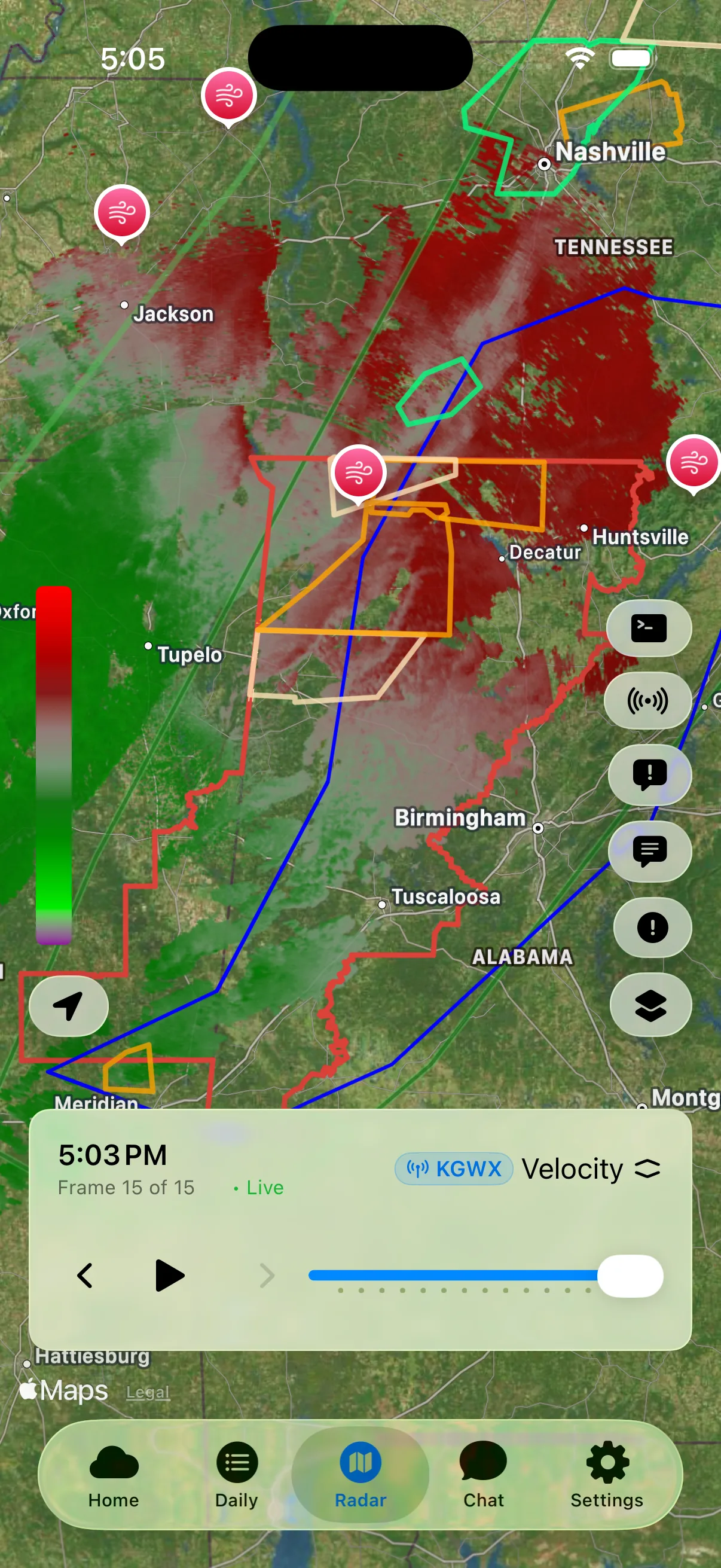
Pro subscribers now have access to high-resolution Level-3 NEXRAD radar data with imagery generated directly by WeatherAI. This delivers some of the highest-quality radar visuals available on any mobile device.
Available Radar Products
| Product | What It Shows |
|---|---|
| Reflectivity | Precipitation intensity and location |
| Velocity | Wind speed and direction toward/away from radar |
| Storm-Relative Velocity | Wind motion with storm movement removed |
| Differential Reflectivity | Particle shape (rain vs. hail vs. debris) |
| Correlation Coefficient | Uniformity of particles (tornado debris detection) |
| Specific Differential Phase | Rain rate estimation, hail detection |
| Hydrometeor Classification | What type of precipitation is falling |
| Hybrid Hydrometeor Classification | Enhanced precipitation type detection |
Select Individual Radar Sites
You can now choose specific NEXRAD radar sites to view data for particular locations, giving you direct access to the source data meteorologists use.
Currently, Pro Radar displays the lowest elevation tilt. Additional tilts are planned for future releases. If this is something you'd find valuable, let us know via Settings → Send Feedback.
Satellite Imagery: See the Atmosphere from Space
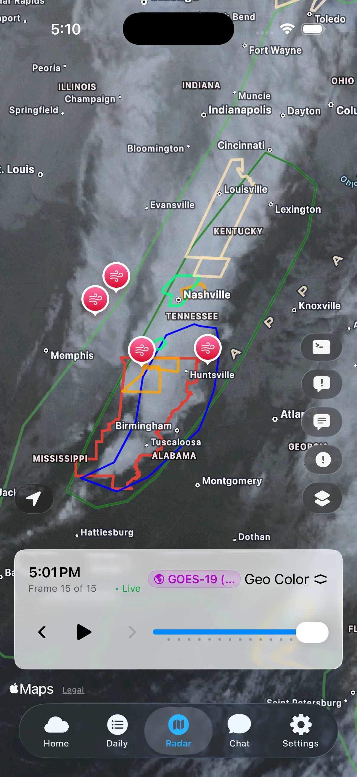
Satellite imagery has arrived in WeatherAI. We now render data from GOES-18 and GOES-19 satellites covering the continental United States (CONUS).
Available Satellite Products
- Band 1 (Blue) - Aerosol detection and coastal water features
- Band 2 (Red) - Daytime cloud and fog identification
- Band 3 (Vegetation) - Vegetation health and burn scars
- Infrared - Cloud-top temperatures, day or night
- Water Vapor - Atmospheric moisture patterns
- True Color - Natural color composite during daylight
- GeoColor - True color by day, infrared by night
Satellite imagery requires a Pro subscription due to the significant server resources needed to process this data. Expansion beyond CONUS may be added in the future based on your feedback.
MRMS Radar: New Layers and Improvements
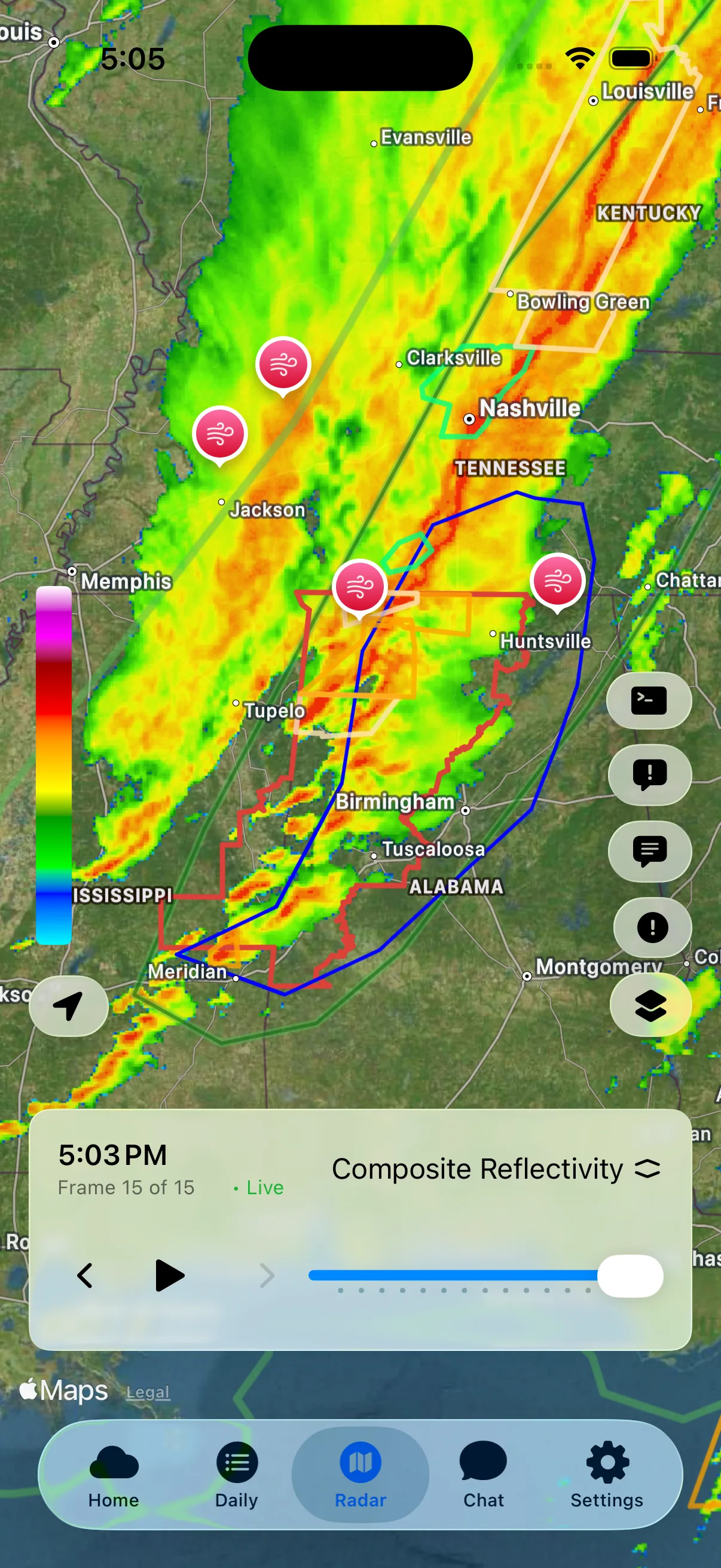
Our Multi-Radar Multi-Sensor (MRMS) radar has been expanded with four new layer types:
- Maximum Estimated Size of Hail (MESH) - See estimated hail sizes across the country
- Low-Level Azimuthal Shear (0-2 km AGL) - Identify rotation in storms for tornado detection
- Precipitation Rate - Real-time rainfall intensity
- Echo Tops (18 dBZ) - Storm height indicators
Additionally, MRMS radar imagery has been enhanced to reduce noise and appear less pixelated. You'll also notice more data frames available when viewing MRMS radar, giving you a longer look at storm evolution.
Improved Radar Interactivity
Better Tappable Layers
Interacting with overlapping radar elements is now much smoother. When multiple elements overlap (watches, warnings, discussions, storm reports), tapping the map presents a list of all available items at that location so you can easily choose what to view.
Adjustable Animation Speed
You can now control radar animation speed directly from the radar settings. Whether you want to quickly scan storm movement or watch details unfold slowly, the choice is yours.
New Notification Types
WeatherAI now supports notifications for:
| Notification Type | Description |
|---|---|
| NWS Area Forecast Discussions | Detailed forecast reasoning from local NWS offices (up to 10 locations) |
| NWS Hazardous Weather Outlooks | Potential hazards for the next 7 days (up to 10 locations) |
| SPC Convective Outlook Risk Areas | Alerts when your locations enter a severe weather risk area (up to 10 locations) |
| SPC Convective Outlook Issuances | Notifications when new convective outlooks are released |
These notifications help you stay ahead of developing weather situations, especially during active weather patterns.
AI Chat for Summary Views
On iOS 26 with Apple Intelligence enabled, you can now ask follow-up questions directly from summary views. This starts an AI chat based on the displayed summary, letting you dig deeper without switching tabs.
For the most comprehensive context and detailed answers, the Chat tab remains the best experience. But for quick follow-ups, this new capability makes getting answers faster than ever.
Population Estimates for Alerts
When viewing U.S. weather alerts, watches, or mesoscale discussions, you'll now see estimated population and housing unit counts within the affected area. This helps you understand the potential human impact of weather events at a glance.
Space Weather: Expanded Imagery and Data
With the sun currently in a period of high activity, we've significantly expanded space weather features:
- Solar imagery - Static and animated views of the sun
- Coronagraphs - See solar wind and coronal mass ejections
- X-ray flux charts - Monitor solar flare activity
- Proton flux charts - Track high-energy particle events
- And more - Comprehensive space weather data on the go
Whether you're tracking aurora potential or monitoring solar activity, WeatherAI now provides detailed space weather insights.
Home Tab Customization
You can now hide and reorder most sections on the Home tab to match your preferences. Head to Settings to configure which sections appear and in what order. Some core sections cannot be hidden, but you have significant control over your home screen layout.
Performance and Technical Improvements
Faster GLM Lightning Updates
The refresh frequency for GLM (Geostationary Lightning Mapper) data has been increased, so lightning activity updates more quickly on the map.
Improved Caching
Local on-device caching has been improved for radar and other app data, resulting in faster load times and smoother performance. You can manually clear the cache at the bottom of the Settings screen, and automatic cache cleanup keeps storage usage under control.
Better NWS Text Formatting
Text formatting has been improved when viewing NWS alerts and watches, SPC mesoscale discussions, and other text-based weather products. These documents are now easier to read and understand.
Overall Performance
Energy-intensive tasks have been addressed and caching further optimized, improving overall app performance and battery efficiency.
Other Improvements
- UI refinements throughout the app for improved usability and a more polished feel
- Crash fix for a rare issue when viewing charts
- Accessibility improvements continuing our investment in making WeatherAI usable for everyone
Rain Viewer Migration
Rain Viewer has discontinued public support for their radar imagery. As a result, Rain Viewer imagery has been removed in this release. Users previously relying on Rain Viewer have been automatically migrated to OpenWeather radar imagery at no additional cost.
Get the Update
WeatherAI 2025.12.1 is available now on the App Store for iPhone, iPad, and Vision Pro. If you have automatic updates enabled, you may already have it.
Have questions about the new features? Ask the AI directly in the app, or reach out through Settings → Send Feedback.
Keep Reading
These articles cover adjacent weather questions, practical explainers, and planning workflows related to this topic.
Guides
How to Read Satellite Imagery: A Complete Guide to Weather From Space
Master visible, infrared, and water vapor satellite imagery. Learn the science behind each channel and how meteorologists use them to track storms.
Weather Education
Radar Beam Height Explained: Why Distance From Radar Matters
Learn how radar beam height affects weather detection. Understand why storms far from radar may appear weaker and how Earth's curvature impacts precipitation detection.
Weather Education
Understanding Flash Floods: Causes, Warnings, and Safety
Learn what causes flash floods, how to spot the risk on radar, the difference between watches, warnings, and emergencies, and critical safety steps that save lives.
Useful Next Stops
Jump from the explainer into tools, feature pages, and seasonal hubs that deepen the topic.
Feature
Professional Radar
Explore high-resolution radar, premium lightning, and satellite layers built for serious weather tracking.
Feature
Severe Weather
Follow outlooks, watches, warnings, and storm signals in one severe-weather workflow.
Guide
How to Read SPC Outlooks
Decode severe weather outlooks, probability maps, and categorical risk levels before storms arrive.
Glossary
Hail
Balls or irregular lumps of ice produced in severe thunderstorms.