Weather Fronts Explained: Cold Front vs Warm Front, Occluded Fronts, and Map Symbols
What cold, warm, stationary, and occluded fronts are, how each is drawn on a weather map, and the clouds, rain, wind shift, temperature, and pressure changes to expect before, during, and after one passes.
Quick Answer: What Is a Weather Front?
A weather front is the boundary between two air masses of different density, usually because one is colder than the other. A moving front is named for the air that is advancing. At a cold front, colder air is pushing in and replacing warmer air. At a warm front, warmer air is moving in and replacing cooler air.
| Front | What is happening | Map symbol | Typical weather |
|---|---|---|---|
| Cold front | Cooler, denser air advances under warmer air | Blue line with triangles | Brief showers or storms, then a wind shift, cooler and drier air, and clearing |
| Warm front | Warmer air advances over cooler air | Red line with half circles | Lowering clouds, then long, steady rain or snow, then milder, more humid air |
| Stationary front | The boundary is barely moving | Alternating red and blue, symbols on opposite sides | Clouds and rain that can linger over the same area for days |
| Occluded front | A cold front has caught up with a warm front | Purple line with triangles and half circles on the same side | A mix of warm and cold front weather near a mature low |
| Dryline | Moist air meets dry air | A line of open, unfilled half circles | A focus for severe storms on the Plains in spring |
The short version of cold front vs warm front: a cold front brings short, sharp weather and a quick change behind it. A warm front brings long, steady weather and a gradual change.
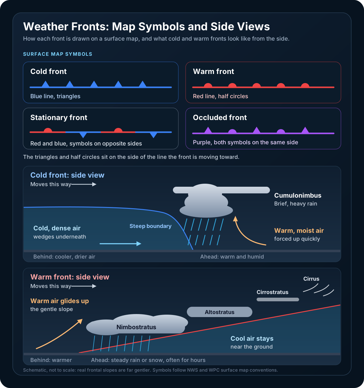
What a Front Actually Is
Air masses take on the temperature and moisture of the regions where they form: cold and dry over northern Canada in winter, warm and humid over the Gulf of Mexico. When two meet, they do not mix easily. The denser cold air stays low, the lighter warm air ends up on top, and the sloping boundary between them is the front.
That slope is why fronts make weather. Whenever warm, moist air is pushed upward along a front, it cools as it rises, its water vapor condenses into cloud, and if the lifting is strong or long enough, rain or snow follows. Lift is one of the four ingredients every storm needs, and fronts are one of its most reliable sources.
Fronts sit in troughs of lower pressure, usually trailing out from the center of a low. For how those systems form and move, see our guide to high and low pressure systems, and for a one-screen comparison of the four types, the glossary entry for a cold front.
Cold Fronts
A cold front is the leading edge of colder, denser air that is advancing and replacing warmer air. Because the cold air is heavy, it plows along the ground and wedges underneath the warm air ahead of it, shoving that air upward.
Friction slows the cold air at the surface, so the nose of the front becomes blunt and steep. A typical cold front slopes about 1:50 to 1:100, which means the frontal surface rises one mile for every 50 to 100 miles you travel back into the cold air. That is steep by atmospheric standards, and it forces warm air up quickly in a narrow zone.
Weather before, during, and after a cold front
| Before | As it passes | After | |
|---|---|---|---|
| Clouds | Increasing high clouds, then towering cumulus and cumulonimbus | Cumulonimbus | Clearing, with scattered cumulus |
| Precipitation | Sometimes scattered showers | Heavy showers or thunderstorms, sometimes hail, or a burst of snow in winter | Showers ending, then clearing |
| Wind | South or southwest | Gusty, shifting | West or northwest |
| Temperature | Warm | Sudden drop | Steadily cooler |
| Dew point | High and steady | Sharp drop | Lower and falling |
| Pressure | Falling steadily | Lowest point, then a sharp rise | Rising steadily |
The wind shift is often the clearest sign a cold front has arrived. In the Northern Hemisphere, winds turn clockwise as it passes, from south or southwest to west or northwest. The other giveaway is the dew point: air that felt sticky an hour earlier suddenly feels crisp.
When the air ahead is warm, humid, and unstable, the storms can organize into a squall line, sometimes led by a shelf cloud and damaging winds. In late fall and winter, cold air behind a strong front crossing the Great Lakes can set off lake effect snow.
Warm Fronts
A warm front is the leading edge of warmer air that is advancing and replacing cooler air. Warm air cannot push the denser cold air out of the way. It has to ride up and over it instead, gliding along the top of a cold wedge that is slow to retreat.
The result is a very gentle slope, roughly 1:200 to 1:300, so the frontal surface rises one mile over 200 to 300 miles. Warm air climbs that slope gradually across a wide area, which builds broad sheets of layered cloud rather than tall, narrow towers. Warm fronts also tend to move more slowly than cold fronts, often about half as fast.
Weather before, during, and after a warm front
| Before | As it passes | After | |
|---|---|---|---|
| Clouds | Cirrus, then cirrostratus, altostratus, nimbostratus, and low stratus or fog | Low stratus | Clearing, with some stratus or cumulus |
| Precipitation | Light to moderate rain, snow, sleet, or freezing rain, often steady for many hours | Drizzle or tapering off | Usually none, though summer showers are possible |
| Wind | East or southeast | Variable, turning south | South or southwest |
| Temperature | Cool, slowly warming | Steady rise | Warmer, then steady |
| Dew point | Rising steadily | Steady | Higher, then steady |
| Pressure | Usually falling | Leveling off | Little change |
The cloud sequence is the classic early warning. Because the slope is so gentle, wispy cirrus can show up hundreds of miles ahead of the surface front, often a day or more before it arrives. The clouds then lower and thicken: a milky veil of cirrostratus that can put a halo around the sun, a gray sheet of altostratus that dims it to a pale disk, and finally thick nimbostratus with steady rain or snow.
In winter, a warm front often puts above-freezing air aloft over a shallow subfreezing layer at the ground, so snow can melt and refreeze into sleet or arrive as freezing rain. Our guide to ice storms, freezing rain, and sleet explains which one you get.
Why Cold Fronts Bring Short, Sharp Storms and Warm Fronts Bring Steady Rain
The difference comes down to three things: slope, speed, and the stability of the air being lifted.
- Slope. A cold front's steep edge lifts warm air almost straight up in a narrow band. A warm front's gentle slope lifts air gradually across a zone that can be hundreds of miles wide.
- Speed. A cold front usually moves faster, so its narrow band of weather sweeps past any one spot quickly. A slower warm front parks its wide band of cloud and precipitation over the same area for hours.
- Stability. The warm, humid air ahead of a cold front is often unstable, so once it is shoved upward it keeps rising on its own and builds cumulonimbus. The air gliding up a warm front is usually more stable, so it spreads out into layers and produces stratiform cloud with lighter, steadier precipitation.
There are exceptions. If the air rising over a warm front is unstable, thunderstorms can be embedded in the steady rain. And some cold fronts, especially slow ones in the cool season, have most of their rain behind the surface front, so it keeps raining for hours after the wind shifts.
Stationary Fronts
A stationary front is a boundary between warm and cold air that is moving very slowly or not at all. Winds on either side tend to blow roughly parallel to it, in opposite directions.
On a map, a stationary front alternates red and blue segments, with the blue triangles pointing toward the warm air and the red half circles pointing toward the cold air, on opposite sides of the line.
Because a stationary front stays put, so does its weather, and clouds and rain can persist over the same area for days. In humid months, storms that keep forming along a stalled front can pass over the same towns one after another, a common setup for flash flooding. Many new lows are also born on stationary fronts: a wave develops along the boundary, starts to spin, and turns part of it into a warm front and part into a cold front.
Occluded Fronts
An occluded front forms when a cold front catches up with a warm front, or with a stationary front. The cold air behind the cold front meets the cool air ahead of the warm front, and the warm air that used to sit between them is lifted off the ground entirely.
If the air behind the front is colder than the air ahead of it, the result is a cold occlusion. If it is milder than the air ahead, it is a warm occlusion. Either way, an occluded front is drawn as a purple line with alternating triangles and half circles, all on the side the front is moving toward.
Occluded fronts usually appear near the center of a mature low that is near or past its peak strength. Their weather combines both parents: a long stretch of cloud and precipitation ahead, like a warm front, then a wind shift with a smaller temperature change. The spot where the cold, warm, and occluded fronts meet is called the triple point, and in spring it can be a focus for severe thunderstorms.
The Dryline
A dryline is a boundary between moist air and dry air, rather than between warm and cold air. In the U.S. it typically runs north to south across the southern and central High Plains in spring and early summer, separating humid air from the Gulf of Mexico to the east from dry desert air from the Southwest to the west.
The temperature can be similar on both sides, but the dew point changes sharply across it. A dryline typically moves east during the afternoon and retreats west at night. It is marked on surface maps by a line of open, unfilled half circles. Storms that form along or just east of it can grow into supercells, which is why it features so often in Plains severe weather forecasts.
How to Read Fronts on a Forecast Map
Surface maps in the U.S. come from NOAA's Weather Prediction Center (WPC), which draws an analysis of the current fronts and pressure centers every three hours and also forecasts where they will be over the next several days. WPC's national forecast charts combine those forecast fronts with the areas where rain, snow, and storms are expected. A few habits make any of these maps easy to read.
- Find the low. Fronts usually radiate from a red L. In the Northern Hemisphere, the cold front typically trails to the south or southwest of the low, and the warm front extends to the east.
- Read the direction from the symbols. Triangles and half circles sit on the side the front is moving toward. A cold front with its triangles pointing east is headed east.
- Look for the kink in the isobars. Isobars, the lines of equal pressure, are drawn every 4 millibars on WPC maps. They bend sharply where they cross a front, because the front sits in a trough of lower pressure. Our guide to barometric pressure covers why falling pressure ahead of a front matters.
- Check what is on each side. Station plots usually show warm, humid air with southerly winds on one side and cooler, drier air with northerly or westerly winds on the other.
- Match the map to the sky. On satellite imagery, a cold front often shows up as a long, narrow band of cloud, and a warm front as a broad shield of layered cloud ahead of a low. Our guide to reading satellite imagery shows what to look for.
Fronts are drawn by forecasters, so a weak one can be hard to place and may shift between maps. The wind shift and the change in temperature and dew point on the ground are what confirm it.
WeatherAI's map can show national forecast charts over its weather layer, so you can see where fronts are expected alongside radar and the rest of the forecast.
Frequently Asked Questions
What is a cold front?
A cold front is the leading edge of a cooler, denser air mass that is advancing and replacing warmer air. The cold air wedges under the warm air and forces it upward, which often produces a narrow band of showers or thunderstorms. After it passes, the wind shifts to the west or northwest, and the temperature and dew point drop.
What is the difference between a cold front and a warm front?
The difference is which air mass is advancing. At a cold front, colder air is moving in under warmer air along a steep boundary, which usually brings short, heavy showers or storms and a quick drop in temperature. At a warm front, warmer air is moving in over cooler air along a gentle slope, which usually brings lowering clouds and long, steady rain or snow, followed by milder and more humid air.
What is an occluded front?
An occluded front forms when a cold front catches up with a warm front or a stationary front and lifts the warm air between them off the ground. It is drawn as a purple line with alternating triangles and half circles on the same side. Occluded fronts usually appear near the center of a mature low pressure system and bring a mix of warm front and cold front weather.
What do the symbols on a weather front mean?
Blue triangles mark a cold front and red half circles mark a warm front, and the symbols sit on the side the front is moving toward. A stationary front alternates red half circles and blue triangles on opposite sides of the line. An occluded front is purple, with triangles and half circles on the same side. A dryline is marked by open, unfilled half circles.
How long does rain last with a warm front?
Rain or snow ahead of a warm front often lasts for many hours. The warm air rises gradually along a gentle slope over a wide area, and warm fronts usually move slowly, so the band of steady precipitation stays over the same place for a long time. It typically tapers to drizzle or ends as the front passes.
What is a stationary front?
A stationary front is a boundary between warm and cold air that is moving very slowly or not at all. Because it stays in place, clouds and rain can persist over the same area for days, and repeated thunderstorms along it can cause flash flooding. When either air mass starts to advance again, the front becomes a cold front or a warm front.
Which way does the wind shift when a front passes?
In the Northern Hemisphere, the wind usually turns clockwise as a front passes. Ahead of a cold front the wind is typically from the south or southwest, and behind it from the west or northwest. Ahead of a warm front it is typically from the east or southeast, and behind it from the south or southwest.
Sources
NWS glossary definitions of front, cold front, warm front, occluded front, and dry line; the WPC guide to surface analysis symbols and terms; and the NOAA JetStream guide to reading weather maps. Frontal slopes and the before-and-after weather sequences are standard textbook values for typical Northern Hemisphere fronts. Individual fronts vary.
Related: High and Low Pressure Systems, Dew Point vs Humidity, and The Four Storm Ingredients.
Keep Reading
These articles cover adjacent weather questions, practical explainers, and planning workflows related to this topic.
Weather Education
High Pressure vs Low Pressure: How Weather Systems Control Your Forecast
Understand how high and low pressure systems work, how to read them on weather maps, and why they determine whether you get sunshine or storms.
Weather Education
What Does a 30% Chance of Rain Mean? Probability of Precipitation Explained
A 30% chance of rain means a 3 in 10 chance that at least 0.01 inch falls at your location during the forecast period. Learn how forecasters build the number, why hourly and daily chances differ, and what it says nothing about.
Weather Education
Spaghetti Models Explained: What Those Tangled Hurricane Lines Actually Mean
Spaghetti models are a tangle of individual forecast tracks, not a forecast. Here is what each line is, what the labels like AVNO and EMX stand for, and how to read the spread instead of the scariest strand.
Useful Next Stops
Jump from the explainer into tools, feature pages, and seasonal hubs that deepen the topic.
Seasonal Hub
Severe Weather Season Guide
A seasonal hub for tornadoes, hail, damaging winds, and storm-prep reading.
Seasonal Hub
Winter Weather Guide
Find practical explainers on snow, freezing rain, wind chill, and winter travel risk.
Guide
Ice Storm vs Freezing Rain vs Sleet
The key differences between winter precipitation types, how each forms, and how to stay safe.
Glossary
Hail
Balls or irregular lumps of ice produced in severe thunderstorms.